
Parco archeologico di Monti di Deu
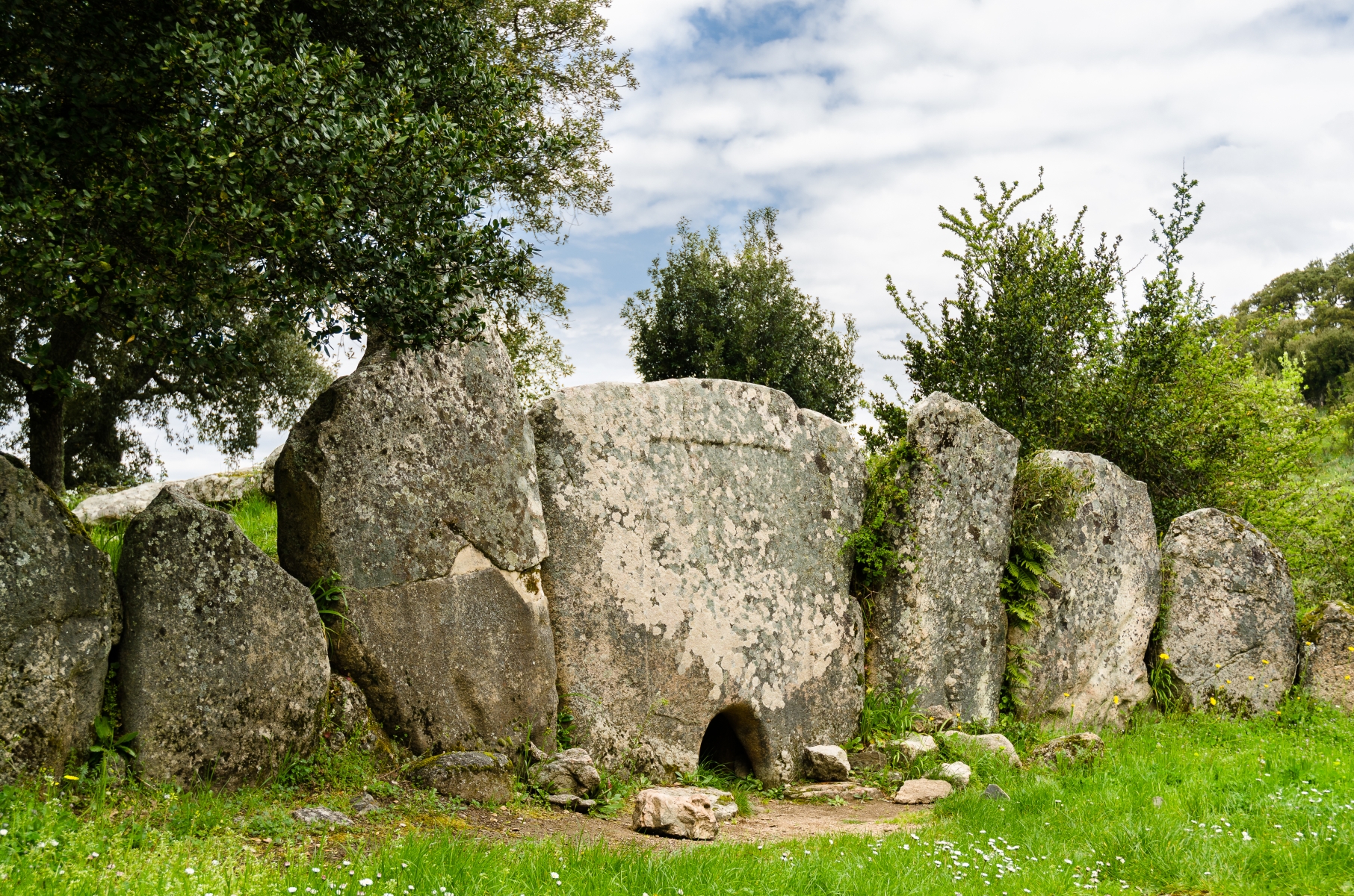
Three nuraghi, a dolmen, a Giants’ Tomb and a sacred well that is still ‘alive’, all contained within a few hundred square metres, in an area that has always inspired a mystical atmosphere, as its name suggests: ‘Monte di Dio’ (Mountain of God). The complex of Monti di Deu is located in the Calangianus countryside, deep in the centre of Gallura, in a setting of woods and granite rocks in Limbara. The material with which the buildings were constructed could only be granite and some of them are still in good condition.
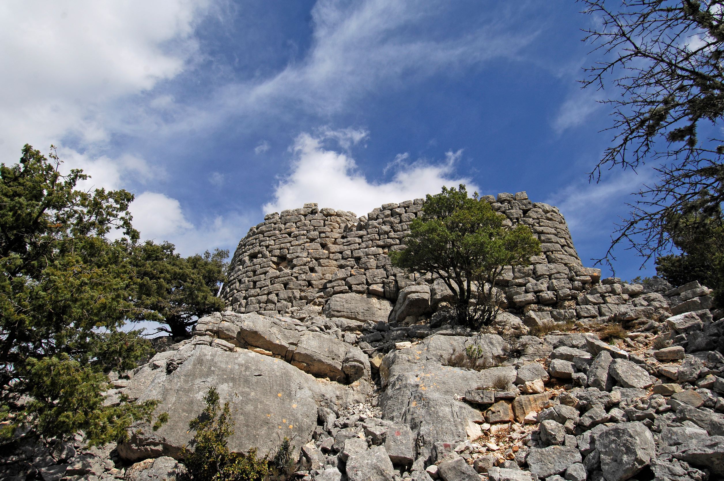
The nuraghe Agnu is a ‘corridor’ type nuraghe, with a horseshoe layout, a solution used to exploit the natural protrusions of the land. You can enter via a trapezoidal architraved entrance, which leads into a corridor. On its sides, you will notice three spaces opening up: on the left, a domed room, on the right a tunnel leading to a natural cavity, while another opening takes you into rectangular room. Next to the nuraghe, you will see the dolmen of the same name.
On the top of a small hill, at the foot of which the Pagghjolu, blocked by the dam of Monti di Deu, forms a small lake, a second nuraghe was built, known by the same name it shares with the locality, the mountain and the dam. It is a mixed corridor and tholos type of nuraghe. The entrance leads to a passage that once provided access to a tower, where there was atholos (false dome) room, now partly collapsed.
On a plain to the north-east of the mountain, you will notice traces of a fence, rows of granite blocks and the base of a city wall: it is here that the centre of the Nuragic village may have stood, defended by another nuraghe, identified by the name of Bonvicinu.
In the heart of a cork oak grove, you can visit the Giants’ Tomb of Pascareddha, dating back to the Middle-Late Bronze Age (17th-15th century BC). The entombment is of the orthostatic type, with an exedra made up of granite slabs driven into the ground and a twelve-metre-long apsidal tomb, made of rows of granite blocks. One of the main and best-preserved elements of the park is the sacred font of Li Paladini, also surrounded by greenery. The wall structure is surprisingly intact and the vein of spring water is still active. The well chamber is preceded by an unevenly-shaped atrium and contains a large stone with a channel for water drainage. The roof is a semi-dome, closed with two granite slabs. There are no steps, because the spring reaches the surface of the ground.
Not just archaeology, Monti di Deu is also an enchanting location thanks to its natural scenery, surrounded by cork oak, oak and alder woods, with monumental trees, and crossed by paths with wooden bridges over streams, waiting to be explored on foot, on horseback or by mountain bike. In the background is the imposing outline of Mount Limbara.

Su Cuaddu de Nixias
It is considered the oldest Giants’ Tomb of all time and is characterised by unusual construction elements in southern Sardinia. Su Cuaddu de Nixias stands in the countryside of Lunamatrona, along the road that leads to nearby Villanovaforru, set in the enchanting hilly landscape of Marmilla, close to the Giara di Siddi. The prehistoric tomb shows distinctive traits that make it fascinating and, at the same time, mysterious. You will first be struck by the arched stele in the centre of the exedra, a central element of the Giants’ Tombs in the centre-north of the Island but rare in southern Sardinia, where the façade generally consists of rows of rock ashlars. The stele, made of a sandstone rock about three metres high with an arched shape at the top, has a front divided into three bands delimited by listels, decorated with a raised border. You will also notice an odd circular hole, created in later periods, which is where the monument gets its name: according to a popular legend, is cuaddus, the horses, used to be tied to the hole. Nixias is the name of the locality. Another unusual element is the positioning of the tomb, pointing in the ‘anomalous’ north-east/south-west direction.
Its origin is in the cultural facies of Monte Claro, around the second half of the third millennium BC. In this period, a lithic cist tomb was built, delimited by four slabs on the sides and a flat arch roof, today corresponding to the final part of the burial chamber. During the Middle Bronze Age (16th-14th century BC), a dolmen corridor chamber was built on it, made from blocks of marl laid ‘on edge’, just over ten metres long and with a monumental exedra on the façade. The slabs of the exedra are set in the ground at decreasing heights starting from the sides of the stele, forming a 14-metre arch.
There are two nuraghi not far from the burial site. For the communities that frequented them, su Cuaddu de Nixias was probably the ‘burial ground’ of reference. The closest is the single-tower nuraghe Trobas, about 500 metres from the tomb. It has an external diameter of thirteen metres and a circular chamber six metres wide, where you will notice two niches. The excavations have revealed traces of a fire, which occurred after the building had already partially collapsed and was probably why it was permanently abandoned. The second nuraghe is in an easterly direction, almost adjacent to the town of Lunamatrona, known as Pitzu Cummu. It stands on a 200-metre-high hill and has a complex structure, consisting of a central tower and four secondary towers, built with basalt blocks. Inside, there is a well with a diameter of one and a half metres; around it, along the slope of the hill, there are traces of other structures, possibly linked to the village.
Sa Domu de Orgia
Not only is it the largest Nuragic megaron temple known to date, but it is the site where a real archaeological ‘treasure’ was discovered, also the protagonist of a popular legend. Sa Domu de Orgia stands at an altitude of about a thousand metres on Monte Cuccureddì, in the territory of Esterzili, a village nestled between the plateaus and valleys of Barbagia di Seulo. The sanctuary, enclosed by an elliptical-shaped fence, is 22 and a half metres long and just under eight metres wide. It consists of a vestibule, obtained by extending the side walls, a cell divided into two spaces and a small opisthodomos on the opposite side to the entrance, probably with the function of making the structure more symmetrical. The construction material is schist, worked in square blocks positioned in horizontal rows.
The most accredited theory regarding its date is that it was built in the Recent Bronze Age, at the end of the 13th century BC, on top of a previous Nuragic village. Inside, you will notice that the vestibule and the rooms of the cell still contain the counter-seat around the perimeter, where votive offerings were placed. It was initially thought that the temple was much more recent, also because of the similarity between its layout and those of Mycenaean temples, but the artefacts found date back to the Nuragic civilisation. The temple would therefore be the result of the influence that people of Greek lineage brought to Sardinia during the Recent Bronze Age. Among these objects, the votive bronzes from the vestibule stand out, representing priestesses, warriors and hunters, similar to those found in the nearby Sanctuary of Santa Vittoria di Serri, suggesting that it was a common ‘workshop’. The sanctuary also revealed another surprise - numerous coins from the Roman era, providing evidence of the continued use of the temple even in later eras, up to more than a thousand years after its construction.
The legend of the priestess Orgia, who was a witch and a fairy at the same time and lived here until the inhabitants of the surrounding villages forced her to leave, lingers within the walls of the temple. The witch decided to take revenge, hiding two baskets, one containing a treasure and the other a swarm of terrible muscas maceddas, killer flies. The fearless people may have dared to go in search of the treasure, but would have caused a massacre by opening the wrong chest, so no one attempted the feat and the ‘booty’ is still hidden within the walls.
Just under three kilometres north of the temple, you will visit the other sacred area of Monte Nuxi-Santa Vittoria, where, in a position of control over nuraghi and villages that had appeared around the course of the Flumendosa river, stands a temple - or perhaps a hut - with a circular layout, a fence and two sacred fountains. On the inner side of the enclosure you will notice traces of a bench, which originally ran around the entire perimeter. Remains from the Roman era have also been found in this site, providing proof of the fact that both areas, Domu de Orgia and Monte Nuxi, have maintained an aura of sacredness for thousands of years, which was respected by the populations who frequented them.
Siligo
Siligo reaches a height of 400 metres on the slopes of Monte Sant’Antonio, an offshoot of Monte Pelao, on which stand the ruins of a Nuragic sanctuary and a castle. Siligo is a small Logudorese village with 900 inhabitants positioned at the centre of an extraordinary landscape, comprised of extinct volcanoes, the volcanic craters of the Meilogu, a natural monument since 1994. The panorama, featuring calcareous and basalt highlands, some quite pointed, other rounded and flattened, is perfect for excursions. Montiju Tundu, Badde Ortolu, Sas Baddes offer views of ‘terraced’ valleys formed by the erosion of the streams. Amongst the finds are testimonies to the extraordinary eruptive activity of 500-600 thousand years ago that see the Monte Santu rise up in its truncated conical shape, on which stands the Chiesa dei Santi Elia e Enoch, which was donated to the Benedictines of Montecassino (11th century), and Monte Ruju, where volcanic dikes deriving from the cooling of lava along narrow rocky fractures can be spied. On the mountain, in the locality of Biddanoa, one highlight is the Chiesa di Nostra Signora di Mesumundu, also known as Santa Maria di Bubalis, built at the end of the 6th century on the remains of a Roman thermal structure and modified by the Sant’Elia monks. Today, it has a central base covered by a hemispherical dome and lateral structures.
On Sant’Antonio mount, together with a sanctuary, there is the Nuragic complex of Monte Sant’Antonio (or Cherchizza), the most extraordinary monument in Siligo, consisting of a temple-well, tower-hut, enclosure, temple in antis, another building and a village - a mysterious world linked to the ritual of water slowly returning to the surface. Nearby are the remains of a medieval castle, mentioned on several occasions, including by Capula, who also made mention of a medieval village around the Chiesa di Sant’Antonio which disappeared in the 15th century. In Coas, an astronomical observatory can be visited at the summit, whilst there is a planetarium in the village. Also in the village is the great cultural attraction of the Museo di Maria Carta, author and interpreter of Sardinian folk music (gosos and muttos), as well as being a poet and actress, who was born and lived in Siligo (1934-94).
The town was also the birthplace of Gavino Ledda, author of ‘Padre Padrone’. Indeed, it is possible to visit the local settings of the famous novel and the film based on the book that won the Palme d’Or in Cannes. The eighth president of the Italian Republic Francesco Cossiga also has ties to this land. The medieval village of Siligo shared the current territory with three other long-gone villages. In addition to Capula, there was also Cherchedu, around the Chiesa di San Nicola in the early 16th century, and Villanova Montesanto, near the Chiesa di San Vincenzo Ferreri (17th century), whose statue, now kept in the parish church of Santa Vittoria, is carried in a procession within the church at the end of August. Housed in the Oratory of Santa Croce is the oak cross used during Holy Week. One event that is not to be missed is the Sagra della Salsiccia e del Novello (sausage and new wine food fair) in December. The excursions combine nature and archaeology, there being an area replete with prehistoric remnants within the extinct craters. In the territory of Siligo are the remains of 25 Protonsuraghi, single-tower Nuragic structures and complexes, including Conzattu, Ponte Molinu, Puttu Ruju and Santu Oltolu.
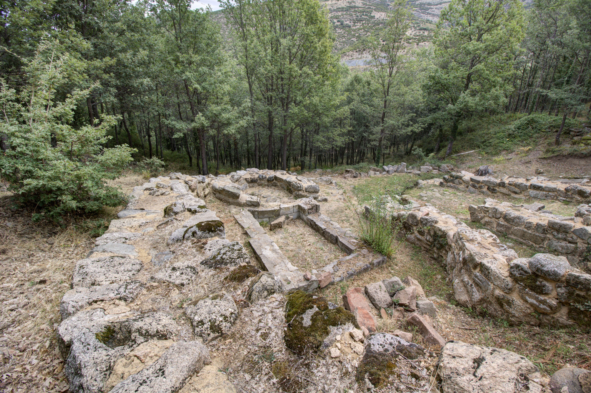
Sanctuary of Gremanu
Crossing the threshold of the temenos, the sacred enclosure, you will be able to imagine the amazement of the ancient visitors before the magnificence of the monument, though the most surprising aspect does not catch the eye right away and is hidden further upstream: it is the only (currently known) example of a Nuragic aqueduct that served the village and the sanctuary of Gremanu. The complex is set in a thick oak forest in the valley of Pratobello, about a thousand metres above sea level between the elevations of Gennargentu, in the territory of Fonni, the ‘highest’ village in Sardinia. The site occupies about seven hectares and is divided into two parts: inside the first, there are the wells and water sources, while further downstream are the residential and religious areas. The springs are enclosed within a semicircular curtain wall, next to which you will notice a basin, probably used for ritual purposes. A small channel directed the water from a spring to a well, then from here a system of canals guided it to the sanctuary.
The religious area, delimited by a 70-metre-long fence, contains various buildings: a temple with a circular layout similar to a nuraghe, a small megaron temple, an apsidal room and two circular huts. The entrance, facing south, led into a semicircular courtyard equipped with counter-seats. On the sides of the entrance door to the temples there are the two huts, perhaps a stopping point for the worshippers. The circular temple has a granite and schist paved floor, a niche and a seat. Traces of fires, the remains of a dividing wall decorated with protomes and zig-zag patterns and a granite ‘socle’ lead us to think that metals were melted here to make votive objects. The megaron temple is eleven metres long, consisting of a vestibule and a cell, inside which you can see a pink granite wall running crosswise and leaning against the back wall, which delimits another room, perhaps intended to contain the ritual hearth. The apsidal temple, made of granite ashlars, also consists of a vestibule and a cell, with a paved floor. The buildings date back to the Recent Bronze Age (13th-12th century BC), while the artefacts found between the sanctuary and the wells date back to the Final Bronze Age (11th century BC). Outside the temples, there are stone bases with holes: here the molten bronze was poured to secure votive objects, swords or small bronze statues.
A kilometre and a half separates the sanctuary from a funeral area, which perhaps belonged to the village: it is the necropolis of Madau, made up of four Tombs of Giants similar to each other, positioned in an amphitheatre layout and facing east. Here, you can also admire the stele of Madau, a granite slab set in the ground next to the first tomb, depicting symbols linked to nature or perhaps to the constellation of the Pleiades.
Santa Maria di Bubalis
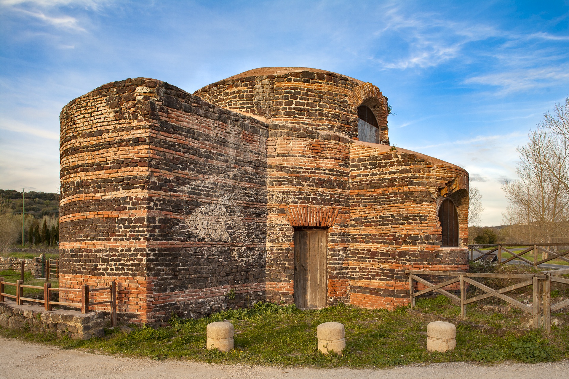
Not only is it a church of inestimable value, but it is also a fascinating puzzle: its central cylindrical body from the Byzantine era stands on a pre-existing Roman thermal structure, but it is not yet clear whether it served as a temple or a baptistery. The original location of the entrance is still a mystery. Questions on the interpretation of the name, or rather of the two ways in which it is known, have continued to be asked for several years. What is certain is that the church of Santa Maria di Bubalis, also known as Nostra Signora di Mesumundu, is among the oldest religious buildings on the Island: its first structure dates back to the 6th-7th century. It stands in Siligo, in the locality known as Biddanoa, rich in aquifers and mineral and thermal springs. During the 11th century, it became the property of the monks of the Montecassino Abbey, who modified its layout by adding an apse to the east and another room on the north side. The two new components were added to the ‘wings’ already built to the south and the west. The oldest parts of the building were built with the opus listatum technique, which alternates rows of bricks and stone ashlars, made of black basalt in this case. The central room is seven metres high, with a diameter of ten metres and is covered by a dome. The interior is simple, with minimal furnishings, illuminated thanks to the large windows built during the most recent renovations. Here, there are traces of the water system linked to the thermal baths. In particular, you will see a channel that flows into a little well with a hole in the middle.
According to some, the term Bubalis comes from Pubulos, or pastures, or from oxen, perhaps with reference to the springs in the area, useful for watering of the animals. Various theories concern the dedication to Nostra Signora di Mesumundu: there could be a connection to the historical territory, the Meilogu, ‘place in between’; or, based on another supposition, Mesumundu means ‘in the middle of the pure water’, with reference to the position of the temple on the thermal spring. According to a more recent theory, the church refers to the model of the Holy Sepulchre in Jerusalem, in particular to the memorial mausoleum, which also has a circular layout. Medius Mundus was a term that, in the early Christian era, identified the place of Christ's resurrection and consequently the centre of the Christian world.
From the church, a walk of just under six kilometres, which initially runs along state road SS 131 and then becomes a trekking trail, will take you to the top of Monte Santo, where the church dedicated to Saints Elias and Enoch (also known as Sant'Elia sul monte), also entrusted to the Benedictines in the 11th century along with Santa Maria di Bubalis. From here, you can admire a 360-degree view of the hills and valleys of Meilogu and, on clear days, you can even see the coast of the Gulf of Asinara to the north. Every year, on Easter Monday, the rural sanctuary is the centre of a celebration, deeply heartfelt by the people of Siligo and by the inhabitants of the neighbouring villages.
Portopaglietto
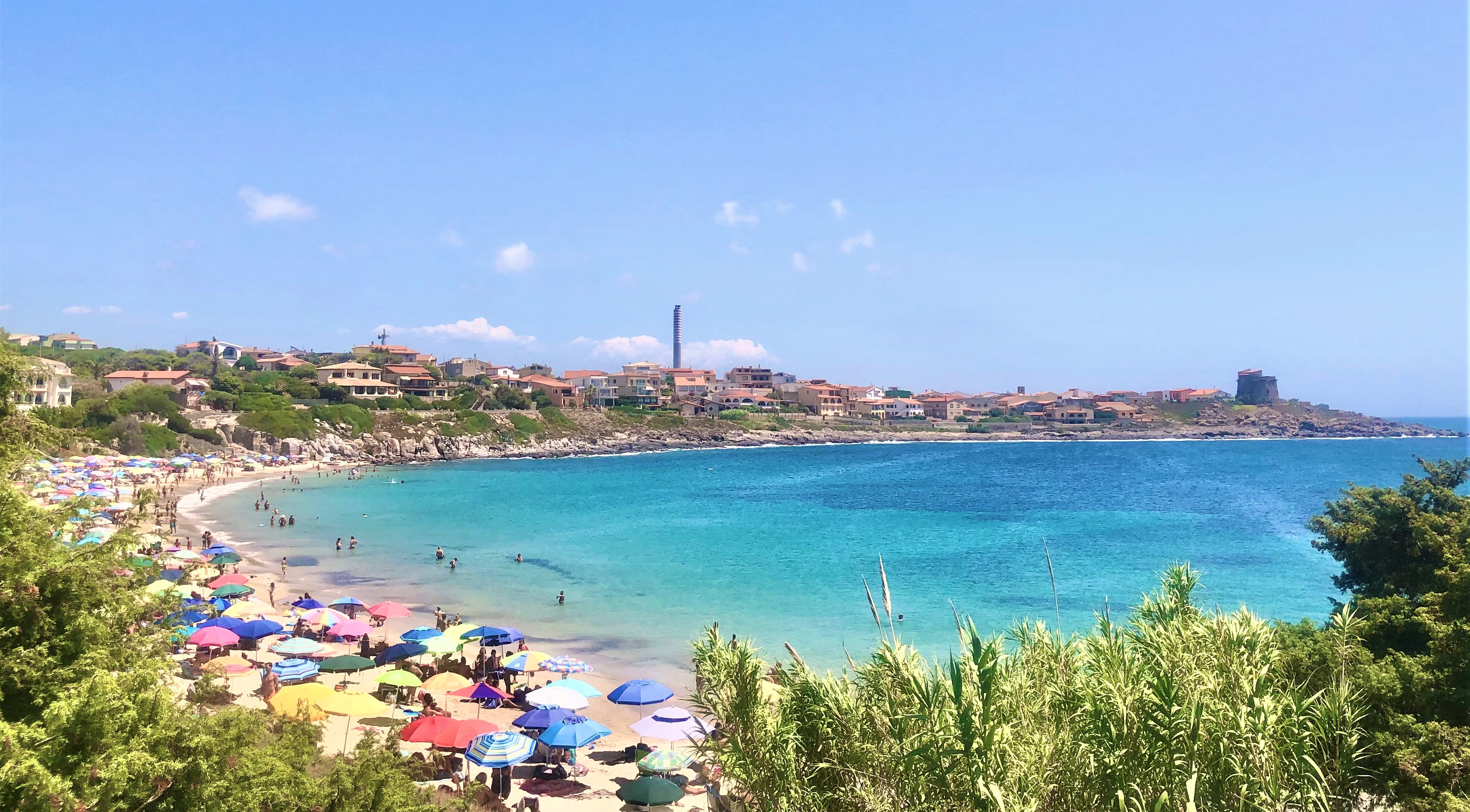
It extends in an arched shape, delimited and sheltered by two cliffs, beyond which you will see the greenery of a large, shady pine forest. The beach of Portopaglietto is located in the northern part of the town of Portoscuso, a village of Spanish origin that has always been focused on fishing, especially tuna. The sandy stretch of the beach, about 250 metres long, has golden hues, shining before a crystal clear blue sea. Off the coast, facing the shore, you will see La Ghinghetta, a rock on which there is a picturesque lighthouse coloured with red and black bands. Looking beyond, you will see the coastal outline of the island of San Pietro. The sides of the beach are rocky up to the foot of the trachyte cliffs and above one of them - the southernmost one - stands the tower of Portoscuso, a Spanish fortress built to defend the coast and the fishermen of tuna and coral, which became the symbol of the town over time. It is still in excellent condition today and is used for cultural events. The northern promontory, on the other hand, acts as a shelter from the winds, especially the northwesterly wind, a feature that, along with the shallow waters and sandy seabed, makes Portopaglietto a suitable destination for families with children. An extensive pine forest, less than two hundred metres away, guarantees some shelter during the hottest hours and also contains a playground.
Portopaglietto is surrounded by unmissable landscapes: a path that leads directly from the beach in a southerly direction - through myrtle bushes and prickly pear plants - will take you to the Spanish tower. From here, on your left you will notice the buildings of the historic tuna fishery of su Pranu, dating back to the 17th century. It stretches around a courtyard overlooking the sea, where you will see a marble sundial. The building is still active for the tuna slaughters, between May and June. Inside, there is the church of Sant'Antonio da Padova.
Then, to the north of Portopaglietto, you will reach various panoramic points along the road that runs alongside the pine forest. The first is sa Cala ‘e su Zurfuru, a rocky cove frequented by numerous snorkelling enthusiasts. Moving beyond, you will come across Capo Altano, featuring abandoned military fortifications and a perfect location for admiring the sunset. From the top of the promontory, as well as San Pietro, you will be able to identify Calasetta and the northern limit of the island of Sant’Antioco, while on the right, you can see the Iglesias coast as far as Nebida.
Tomba di Giganti di San Cosimo
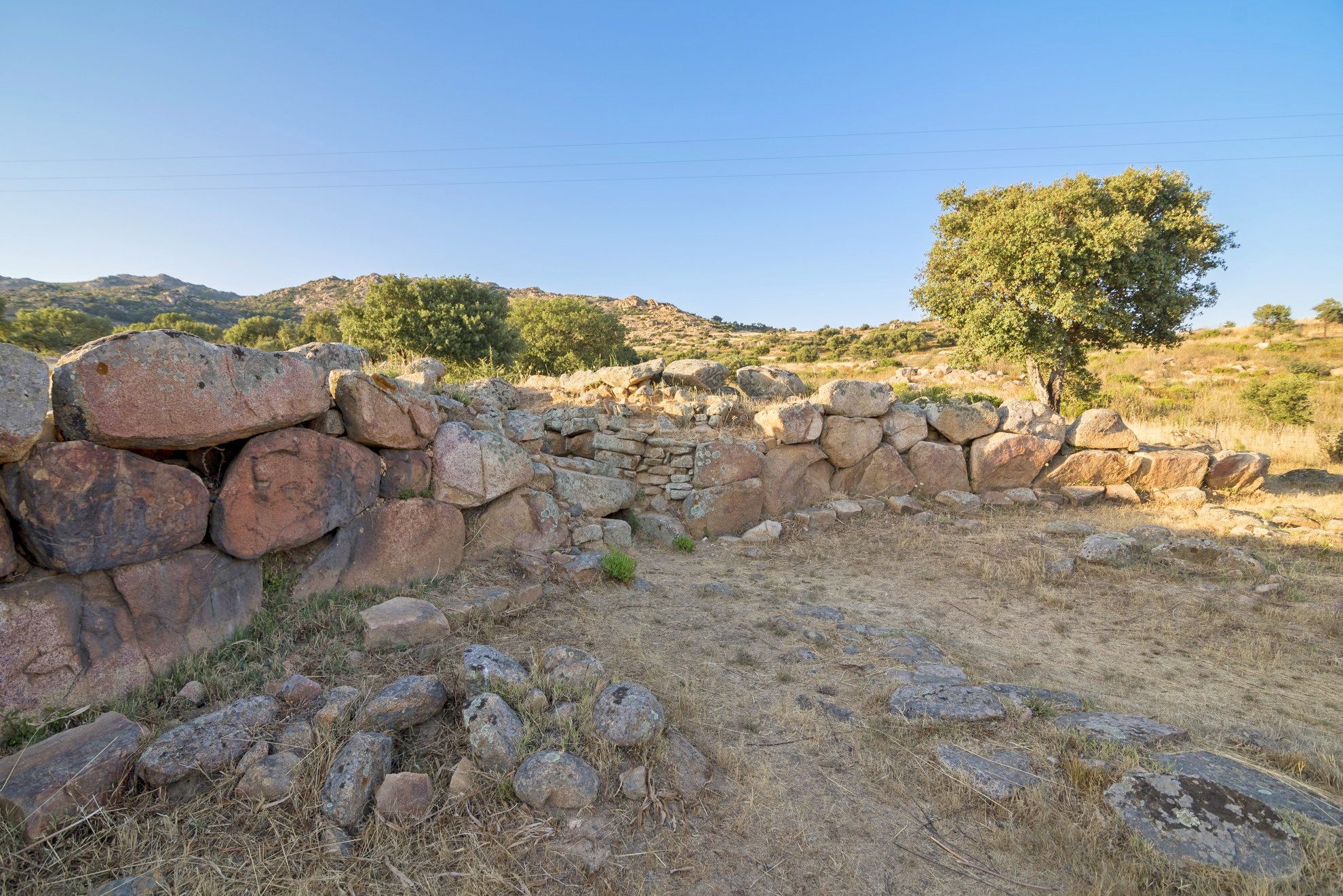
It is one of the largest megalithic constructions on the Island, along with a smaller-scale ‘copy’, located not far from other Nuragic ruins - still to be investigated - and it has unearthed an artefact that may be the oldest Mycenaean import found in a Sardinian archaeological site. The Giants’ Tomb of San Cosimo is found in a valley in the territory of Gonnosfanadiga that opens like a natural amphitheatre at the foot of the Terra Maistus mount, in a landscape dominated by the outline of Monte Linas. The area contains a real archaeological park, in which there is also another smaller tomb of the same type, and two nuraghi.
Also known as sa grutta de santu Giuanni, the tomb was considered by the ‘father’ of Sardinian archaeology Giovanni Lilliu - in his work entitled ‘La Civiltà dei Sardi’ (the Sardinian Civilisation) - to be the largest Giants’ Tomb known up until that time: it is thirty metres long and its exedra is 26 metres wide. It was built from granite, obtained in the surrounding area. Based on the artefacts discovered inside and around it, the monument has been dated between the 15th and 14th centuries BC, during the Middle Bronze Age. The façade is typical of Giants’ Tombs in central-southern Sardinia, based on rows and an architraved entrance without a stele. Along the external perimeter you will see some stones against the base, forming a step. This solution served two purposes: to make the structure more solid and to prevent rainwater from seeping in. A small corridor leads to the actual chamber, with a rectangular layout and a truncated-ogival section. The original floor, which has only survived in a few places, consisted of a surface of smooth stones of different sizes and pebbles, placed on a natural bank of granite rock. Among the artefacts unearthed during the excavations – on display at the Archaeological Museum of Villa Abbas in Sardara – you can admire carinated cups, a glass, a few containers and above all beads made of green vitreous paste, which have been considered a Mycenaean product and, therefore, the necklace they were part of could be the oldest jewel found in Sardinia coming from Greece. Three concentric fences surround the tomb. The largest one extends towards the north-west. In the same direction, about seventy metres away, you will notice the second tomb. The same type of construction was used to created it, but it is decidedly smaller in size: the chamber is just under three metres long and the exedra is four meters wide.
A short distance from the necropolis, you’ll find the nuraghe San Cosimo, also known as su Bruncu ‘e s’Orcu, and San Cosimo II, probably single-towered, both still to be excavated. The site of the first nuraghe corresponds to the territory of the medieval village of Serru, which did not survive an attack inflicted by Saracen pirates in the early 17th century. The only traces of the village that still exist are the ruins of the small church, also dedicated to San Cosimo, giving a name to the locality, the tomb and the nuraghe.
Punta Sa Berritta
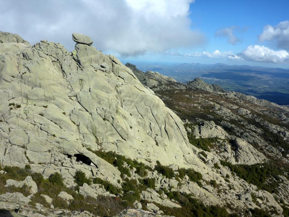
A rare and perhaps unique granite arch next to a bank of rock shaped like a parallelepiped remain balanced on the narrow peak of an elevation, over 1300 metres high, and no one knows how. The two spectacular natural monuments are located in Punta sa Berritta, the highest peak - 1362 metres - of Monte Limbara, on the side that falls within the territory of Berchidda. From here and from the other peaks - Balistreri (1359 metres) and Bandiera (1345) -, which can be reached via marked trails, you can admire the enchanting landscape of the whole of Gallura. You’ll have a view stretching from the mountains of Aggius to the plateau of Tempio Pausania and, further in the distance, to Olbia, Golfo Aranci, the Costa Smeralda and the Maddalena Archipelago. On a clear day, you can also see the cliffs of Bonifacio.
The excursions taking you to Punta sa Berritta and allowing you to admire the curious rock formation and the spectacular Suprappare arch generally start from Vallicciola, at an altitude of just over a thousand metres, where you will find resting and picnic areas with water sources and information boards. You can visit the little Church of Madonna della Neve (Madonna of the Snow), built in granite in the 1990s on the ruins of a pre-existing sanctuary constructed at the beginning of the same century. The church stands on a panoramic ‘terrace’: from up there, you will be impressed by the contrast between the green of the woods and the grey of the granite, shaped by wind and water into rounded and original shapes. You will also see Tafoni, cavities used in the past as burial places, homes and shelters for animals.
The Park of Limbara occupies almost twenty thousand hectares between the territories of Tempio, Calangianus, Monti, Berchidda and Oschiri. The paths wind between shrubs of strawberry tree, heather, phillyrea and lentisk, through holly, holm oak and yew tree woods. At higher altitudes, the mountain becomes more arid: rockrose, helichrysum and Garden Juniper ‘Nana’ appear here. There is no shortage of native species, such as the currant and the Limbara rose, along with varieties of broom and thyme. The wildlife is no less rich: you can see wild boars, weasels, wild cats, hares and martens, as well as the Bedriaga’s rock lizard, which only lives in Sardinia and Corsica. Among the birds, jays, partridges and woodpeckers are at home here, while golden eagles and peregrine falcons circle around the summit. Limbara can be explored in an off-road vehicle, a motocross bike, a mountain bike or along the properly-marked trekking trails. Several torrents that cross it are a destination for canyoning enthusiasts. Among the sports that can be enjoyed on the peaks, there is also climbing, without forgetting that this is a clean area, where inserting artificial anchors or drilling holes is prohibited.
Nuraghe Mereu
It stands on a rocky outcrop overlooking one of the deepest canyons in Europe and, thanks to its light limestone blocks, it stands out in the heart of a dense forest. The nuraghe Mereu stands at a height of 835 metres on the Supramonte of Orgosolo. The inhabitants of this Barbagia village call it nuraghe intro ‘e padente, or ‘the nuraghe inside the wood’. The Mereu is, in fact, difficult to see if observed from below and from a distance, as it is surrounded by the forest of Montes. However, once you reach it, you will be able to admire a breathtaking landscape, especially the walls of the spectacular gorge of Gorropu to the north-east. Then, to the south, you can see the outlines of the Supramonte of Orgosolo and that of Urzulei.
The nuraghe, built entirely from limestone blocks found on site, has a complex structure, with a trilobate layout, a keep and two secondary towers connected by a curtain wall. Still standing are the main tower with a tholos roof, still intact and about five metres high, and the bastion on the west side. The original entrance was on the south side and led into a corridor that is still partly accessible and at the end of which there is a connecting room between the keep and one of the towers, now partially collapsed. The third tower, however, is now a ruin. The stairwell, to the left of the entrance and leading to the upper terrace, is also partially remaining. To the west of the fortress, you will notice several traces of the village huts, while, hidden inside the wood, there are a few Tombs of Giants, linked to the same settlement.
800 metres further on, heading north-east, you will reach the single-tower nuraghe Presethu Tortu, also known as nuraghe Gorropu due to its closeness to the gorge. It is also built in white limestone and is located on the edge of a rock wall, which conditioned its structure. On the east side you will notice a bastion more than three metres high, still in good condition, while the tower is currently six metres high. Like the Mereu, the Presethu Tortu is surrounded by traces of huts. The path between the two nuraghi crosses the dense forest, marked by stones purposely placed along the way. A visit to the two nuraghi ‘guarded’ by the forest of Montes will take you into the thousand-year-old wood of sas Baddes, one of the most ancient expanses of holm oaks in Europe, occupying a thousand hectares. A short distance away, a visit to the most famous natural monument, the gorge of Gorropu, on the border between the Barbagia area of Orgosolo and the Ogliastra area of Urzulei, is a must. The canyon with its majestic walls, a kilometre and a half long, was created by the patient erosion of the river Flumineddu, and it is a destination for trekking enthusiasts from all over the world.