
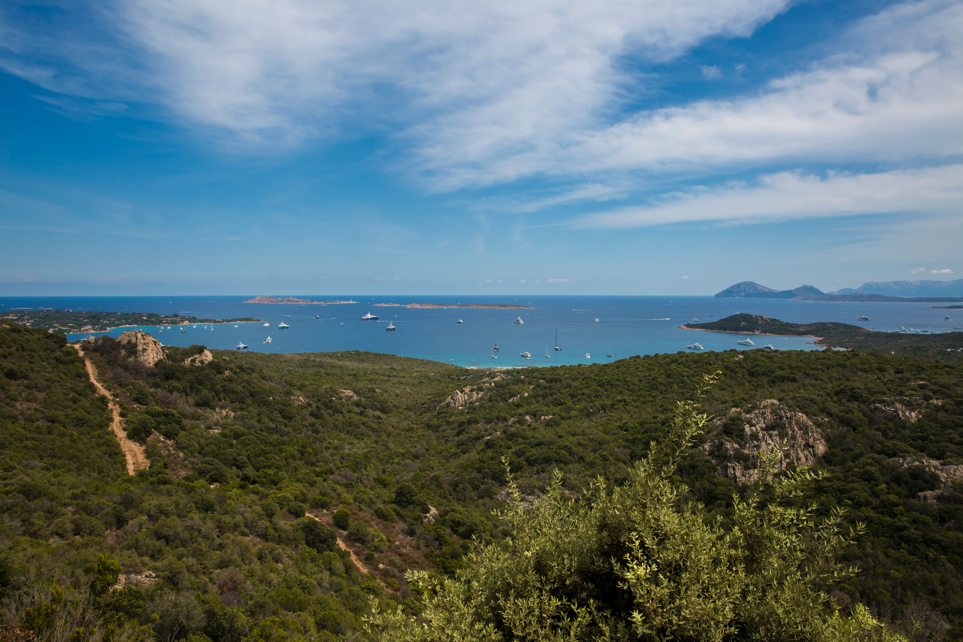
Liscia Ruja
Crystal clear water, emerald green like the name of the coast it belongs to (smeralda means emerald), white sand - with golden reflections - turning pink as it meets the sea and Mediterranean scrub all around, protecting it. Liscia Ruja is one of the most famous and biggest beaches on the Costa Smeralda, located in the southern part of the gulf, a stone’s throw from the most renowned hotels of the entire coast.
A stretch of coastline is made up of a series of small bays enriched by strawberry trees, rock roses, junipers and white lilies leading to the beaches of Li ‘Itriceddhi, Petra Ruja and Razza di Junco. Liscia Ruja is a mixture of unspoilt nature and stretches of modernity, thanks to the facilities allowing you to enjoy every service useful for bathing.
Liscia Ruja is surrounded by greenery and overlooks a small closed gulf in front of the islands of Soffi, Le Camere and Mortorio. The beach can be reached via a small dirt road. Despite its wild appearance, it is one of the most highly-frequented along the entire coast and is well-known by the jet set and international celebrities. Thanks to its size, the beach has large free stretches next to bathing establishments, equipped for renting deckchairs and beach umbrellas, canoes, kayaks and rubber dinghies. There is no shortage of clubs, restaurants and hotels among the most renowned in the entire area. On 15 August, the day of Ferragosto, a very popular party is organised in Liscia Ruja, in perfect Costa Smeralda style.
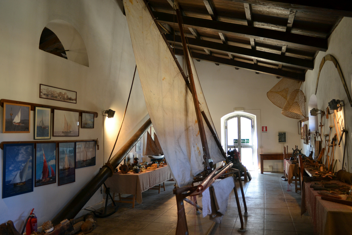
Museum of the Sea
It tells the story of the sea and life on the archipelago over the centuries. Staged and inaugurated in 2006 in Caprera - connected by a long artificial isthmus to the ‘big sister’ La Maddalena - by the managing authority of the Archipelago National Park, in collaboration with the Italia Nostra Association, the Museum of the Sea and Maritime Traditions will accompany you in the discovery of the history and culture of La Maddalena relived through the sea routes, on a chronological journey divided into sections, from prehistory (starting from the Neolithic period) to today.
The collection is made up of artefacts donated by institutions, volunteers of the association, fishermen and other private individuals: historical images, maritime and military documents, scale models, remains of ancient and modern sailing and motor boats, navigation instruments, work tools, machinery for engines and fishing equipment. The most distinctive objects are ancient, such as the Tabula Peutinger - a map of Roman origin that portrays the entire street map of the Empire in the 3rd-4th century AD -, and the ‘Mother Goddess’ made of granite, or they refer to prehistory, such as the ‘wooden sculptures’ by Bruschi depicting Nuragic deities. Others are modern, such as a sundial engraved on copper plates, the twin-pan balance and a precision calibre gauge. The visit to the rooms is accompanied by the narration of historical events.
Caprera is the second largest island of the archipelago and the last residence of Giuseppe Garibaldi. On the subject of the Hero of The Two Worlds and places of culture, don't miss the Compendio Garibaldino, one of the most frequently visited museums in Italy. Then a dip in the sea is a must, observing the limits imposed by the national park. In the area under the full protection scheme, don’t miss Cala Coticcio, the ‘Sardinian Tahiti’. To the south-east, Cala Portese (or dei Due Mari) is noteworthy, where the water bathes both sides of the inlet, as is the splendid Spiaggia del Relitto (Beach of the Wreckage). To the west, worthy of a visit are the blue waters of Cala Napoletana, the wild nature of Cala Garibaldi and the expanse of light sand of Cala Serena.
Villa Abbas
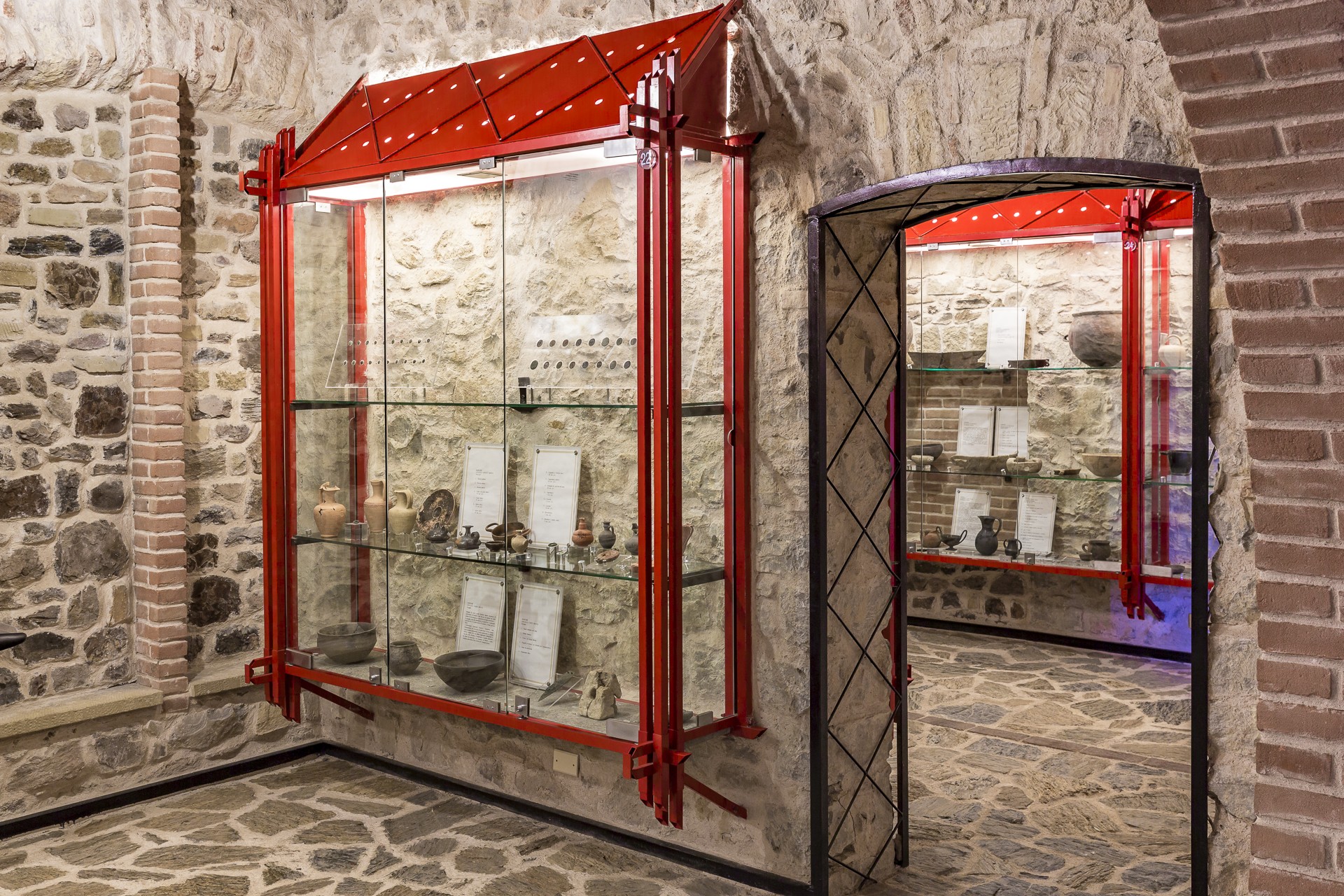
In the centre of Sardara you’ll enjoy a thrilling virtual journey back in time to the mysterious Nuragic and pre-Nuragic periods, delve into fascinating Punic relics, and into Rome’s Republican and Imperial eras. Housed in a lovely early 20th century building, the archaeology museum at Villa Abbas is worth a visit. Before the building was renovated and inaugurated (1997), it was a municipal building, a garrison and then a school. The exhibition is spread over 8 halls containing display cases and water wells. It includes items from the most important archaeological sites in the Medio Campidano area all the way to the Cagliari hinterland along route 131 (the island’s main motorway). The first hall is an educational one that will teach you how to ‘read’ the exhibits. Here you’ll find technical illustrations of the digs, complete with historical and chronological data, and a range of ceramic items dating from the Neolithic to the late Imperial Era. Every hall, and its items, is accompanied by illustrational panels.
The subject of the second hall is the Sanctuary of Sant’Anastasia in the town of Sardara. It takes its name from the little byzantine Church that was built over prehistoric ruins. The exhibit features items discovered in a well temple and a Nuragic village. A corridor, alongside a well in which Roman era tombs from the necropolis of Terr’e Cresia were reconstructed, leads to the third hall. Here you’ll find exact reproductions of wells, bones, and ceramic and metal objects. The fourth and fifth halls contain finds from the same site, as well as from cremation and inhumation tombs. The remaining section of the fifth hall offers an overview of the most important finds in the Sardara area, including bronze Nuragic archers. The sixth hall is devoted to the castle of Monreale, with its surrounding village and walls. The finds here include ancient Iberian, Italian, African and local ceramic finds, as well as objects made of wood, bone and metal. One of the display cases takes you into the daily life of the castle. The well exhibit offers a reproduction of how items were made from clay. The last two halls are devoted to the sites that came to light during the construction of the 131 motorway and include prehistoric relics from Padru Jossu (Sanluri), Sant’Antonio (in Serrenti) and San Sperate, but more importantly, clay ex-votos from the Punic Age that came from the ancient city of Neapolis.

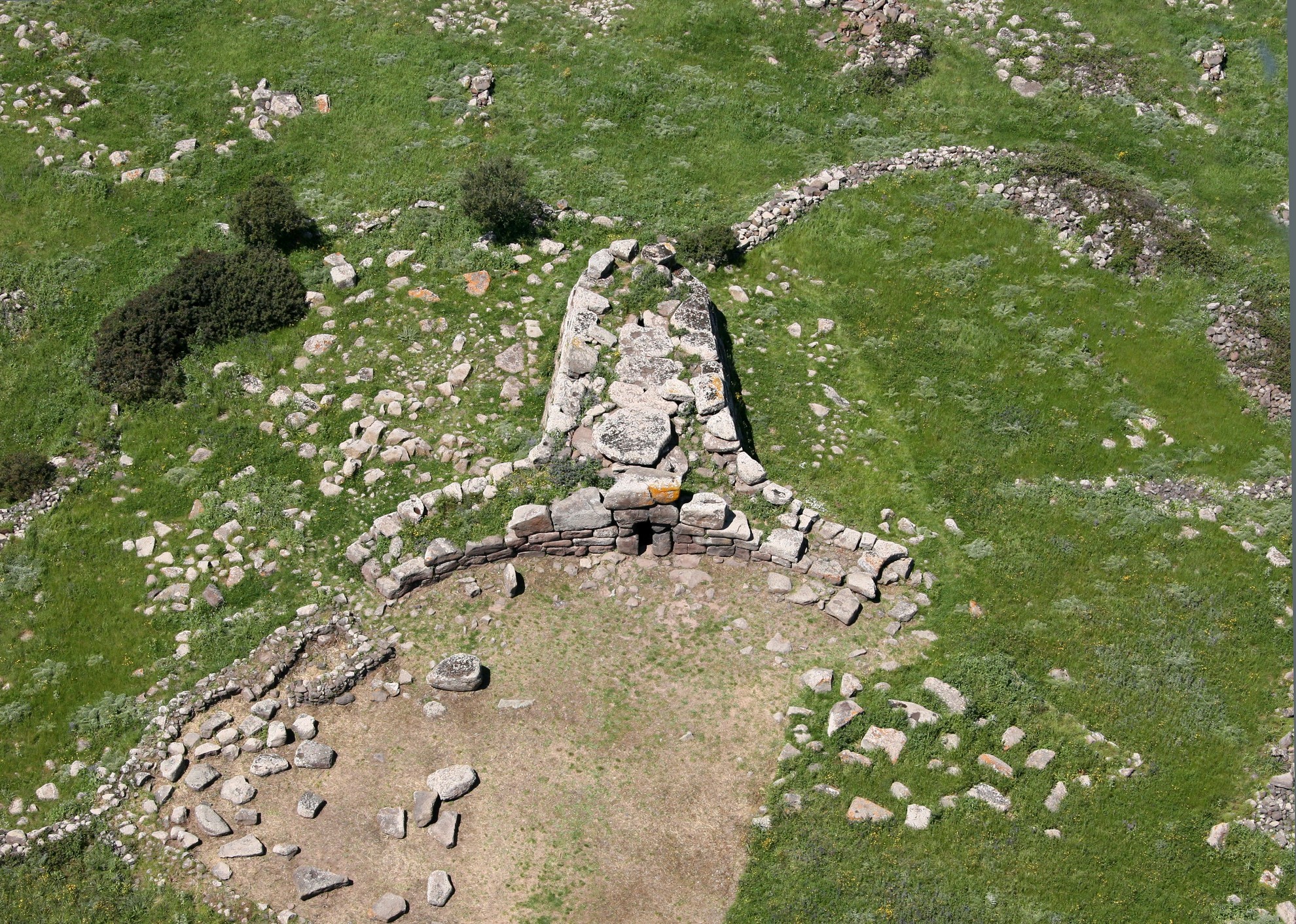
Nuraghe and necropolis of Brodu
This evidence is carved into the slopes of a trachyte hill, just below a single-tower nuraghe, and since 2025 has been part of the Sardinian Unesco World Heritage Sites. The four hypogeic tombs of Brodu are located in the territory of Oniferi, about four kilometres from the residential area. After leaving the provincial road towards Macomer, you can reach them on foot by wading across a stream and climbing the slope beneath the nuraghe of the same name, which dominates the territory from the top of the hill. Two of the tombs are notable for their size and state of preservation. However, little remains of the other two and of the nuraghe, the tower of which is partly buried.
The necropolis reveals phases of different cultures, covering a period between 3200 and 1600 BC. The first hypogeum is made up of an elliptical cell with two pillars in the centre. Of the second, you can see the imitation of a single-pitched roof in the ceiling. Then there are the two best-preserved domus. The third has a vestibule from which you can enter an anteroom, in the back wall of which there is a door that has a raised triple bovine protome above it and leads into the larger central cell. Along the sides of the burial chamber you will see raised rooms and the entrance to a secondary room in the back wall. Tomb 4 is the one that will impress you the most, especially for its architecture and symbolic elements carved on the walls. The tomb is T-shaped and is preceded by a monumental dromos. After passing through an atrium, you will enter a quadrangular anteroom with a small niche and a sloping ceiling. There is a door in the back wall, leading to the central burial chamber. This door also has a carved cornice and a beautiful bas-relief above it, depicting four stylised bovine horns. Here, there are also traces of a red colour on the walls, like in the third tomb. In the walls, there are two entrances that provide access to small lateral cells.
The territory of Oniferi is rich in evidence of the Nuragic and pre-Nuragic era: in addition to the site of Brodu, don't miss the opportunity to visit the large and unique necropolis of sas Concas, a few kilometres away.

Poltu Quatu
In the northern part of Gallura, in the territory of Arzachena, there is a small fjord featuring pink granitic rocks, shaped by the wind, overlooking one of the most beautiful landscapes in Sardinia: the Maddalena Archipelago. Here lies Poltu Quatu, a small village dedicated to the seafaring life of the past and located in a strategic position in a natural inlet nestled in the typically Mediterranean landscape, an exclusive place with a crystal clear sea and Costa Smeralda social life. It emerged in 1987, as a landing place for small and medium-sized boats. Over time, the village has become a destination for the jet-set and is now surrounded by hotels of various categories, famous restaurants, designer shops and diving clubs.
Poltu Quatu is surrounded by granitic rocks emerging from the scrub and is characterised by small houses perched on the hills overlooking the sea. The houses revolve around a little central square and a small harbour, Marina dell'Orso, which has 320 moorings that are also occupied by large yachts, and overlooks the island of Caprera and other islands of the archipelago, which you can reach and explore by boat from the harbour.
By land, just a stone’s throw from the village, you can reach the magnificent Costa Smeralda beaches, including Capriccioli, the coves of Pitrizza e di Volpe and Liscia di Vacca and those of Palau, among which Porto Faro, Porto Rafael and Cala Trana stand out.

Punta Sardegna
A quadrangular tower 13 metres high, resting on two floors below it and standing like a sentinel of the sea on the northeastern coast of Sardinia, overlooking the Strait of Bonifacio. It is the distinctive lighthouse of Punta Sardegna, a tourist resort in the territory of Palau, which is one kilometre away, exactly as far as the captivating Porto Rafael. The construction of the lighthouse dates back to 1913 and was carried out by the Genio Civile (Civil Engineering Department). After decades of abandonment, the Coastal Observatory of the Natural Underwater Environment (OCEANS) has been located there since 1995. One of its distinctive features is that the beacon stands on one of the terraces and not on the tower.
From the lighthouse, there is a view of the island of Spargi and of Cala Corsara. Nearby, you’ll find the Batteria di Monte Altura, a fortification dating back to 1800 that, thanks to its excellent state of preservation, is open for guided tours and, in the summer season, it hosts concerts and cultural events. From Punta Sardegna, you can get to the inlet of Cala Trana with its small sandy shore. Then, continuing west, there is Poltu Cuncatu, an inlet of limestone rocks.
Around the tip, the natural and scenic characteristics of a stretch of coast overlooking the Maddalena Archipelago have remained intact: this is the best place for observing it. Throughout the area, there are services equipped for bathing and sea excursions for snorkelling and diving enthusiasts. Considering the closeness of the Costa Smeralda tourist villages, you can stay in exclusive hotels in perfect harmony with the environment.
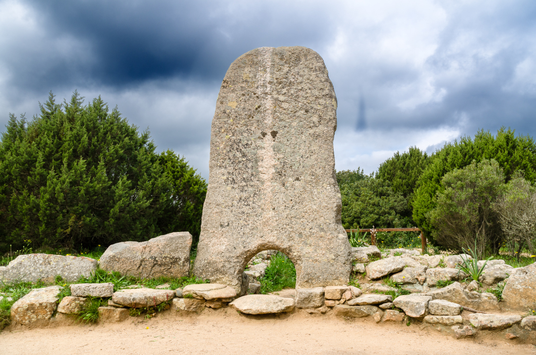
Sa Dom'e s'Orku
“It is not a bull's head but a woman giving birth - not a male but a female emblem”. A recent theory regarding the nature of the Tombs of Giants questions the classic and undisputed definition of ‘bull protome’ used to indicate the shape of the approximately 800 collective burials dating back to the Nuragic era discovered on the Island. The fascinating hypothesis also involves one of the most significant and best-preserved tombs: sa Dom’e s’Orku, an extraordinary example of Bronze Age funerary architecture. The name, ‘the ogre's house’, often returns in this type of construction, to symbolise and increase the mystery and fear. Imposing and almost intact, the tomb stands out on a slight elevation (260 metres), on the northwestern side of the plateau of su Pranu or Giara di Siddi, with an enchanting view of the small town of Marmilla, just over six kilometres from the monument.
The burial building has a megalithic structure, meaning that it was made from medium-large sized blocks of dark basalt, extracted from the rocks of the ‘giara’ (basalt plateau), well worked and positioned in even rows. Despite the cyclopean technique, the tomb is, in fact, a row-type building. The front is semicircular - partially restored by a mid-20th century intervention. It is 18 metres wide, with a curved shape, and at one time was enclosed by a bench seat, a few traces of which still remain. Its distinctive feature is that the blocks used in the three rows at the base are smaller than those in the upper rows. The ‘door’ opens in the middle and is just over one metre high, with a formidable architrave above it. In the space in front of the entrance, rituals linked to the veneration of the dead took place. The body of the tomb, which is two and a half metres high and 15 metres long, is closed at the rear in a semicircle by a large monumental apse. The roof is made from flat granite slabs. Large stones, protruding walls and a flat arch roof give the tomb of Siddi an archaic image and suggest an earlier date than, for example, another famous Nuragic burial place in the Campidano area, is Concias in Quartucciu, made of smaller stones and with pointed arch roofing.
As soon as you enter sa Domu, you will see a large raised niche on the left, understood to be the room for the funeral and votive offerings. The cell shares similarities with domus de Janas and dolmens, Neolithic and Copper Age monuments. The floor on which the dead were placed was a pebble ‘bed’. It is thought that up to 300 bodies could be laid out in the burial chamber, accumulated progressively, which is ten metres long with a trapezoidal section. However, no bone fragments have been found, while the remains of grave objects are abundant and are mostly ceramic, dating the tomb to the Middle Bronze Age (16th-14th century BC). The excavations have also brought to light fragments of a bowl with Neo-Punic writing, Roman table ceramics and eighteenth-century Savoy coins, which bear witness to the (improper) reuse of the tomb up until recent times.
The Giara di Siddi, a cradle of prehistoric civilisations, is an open-air museum. The domu di Scaba ‘e Arriu dates back to the final part of the Neolithic period. The Bronze Age is documented not only by the sa Dom’e s’Orku, but also by about twenty nuraghi. The closest to the tomb is the Conca sa Cresia complex, while the most captivating (and mysterious) is sa Fogaia, which falls under the category of ‘corridor’ nuraghe but consists of three different bodies plus other secondary ones. It dominates the surrounding area from a cliff and is nestled in a setting of holm oaks and the Mediterranean nature of the park of the same name. The Roman era left behind tombs, remains of inhabited areas and coins. The plateau is a journey between the prehistoric era and nature, as is the whole territory of Siddi, a village characterised by narrow streets and ‘courtyard’ houses. The seventeenth-century Casa Steri is home to the Museum of Farming and Food Traditions, documenting the knowledge and flavours of the Marmilla region. Other places not to be missed are the Bird Museum of Sardinia and the church of San Michele Arcangelo, the smallest Romanesque sanctuary on the Island, with anthropomorphic reliefs carved in the architrave over the portal, a unique Sardinian medieval work of art.
Nostra Signora di Gonare
It is the ‘highest’ church on the island, as well as being the most evocative Marian sanctuary. Nostra Signora di Gonare stands in a marvellous setting at an altitude of 1100 metres. The mountain range, with its three limestone peaks (Gonare, Gonareddu and Punta Lotzori) and surrounded by grey granites, dominates the whole of central Sardinia. From the central peak, where the church stands, you can see the sea to the east and to the west on clear days. A part of the sanctuary walls belongs to the Parish Church of Sant’Andrea di Orani and the other part belongs to that of San Michele Arcangelo in Sarule. The same goes for the property of the cumbessias, ancient dwellings with porticoes for worshippers during celebrations, the most ancient of which were built next to the church, while others were built further downstream.
There is an aura of legend around the origins of Nostra Signora di Gonare. The sanctuary is the work of the judge of Torres, Gonario, who, upon his return from a pilgrimage to the Holy Land, found himself in danger during a violent storm and promised the Virgin Mary that, in exchange for his life, he would build a church dedicated to her on the first site he caught sight of. Mount Gonare lit up, guiding him to safety, and the storm died down. The sanctuary was built on top of it. The first historical evidence of the cult of the Madonna of Gonare, deeply-rooted in central Sardinia, dates back to 1341: a payment of money by the rector of Gonare was discovered. Other evidence was found in the Chorographia Sardiniae (mid-16th century). In addition, the bell of the sanctuary dates back to 1587. A report by the bishop of Alghero (1608) describes the progress of the building taking place, which ended in 1619: the small sanctuary was extended to its current size. It was consecrated in 1912 and 60 years later, before the eyes of 50 thousand worshippers, the solemn coronation of Madonna di Gonare took place.
Many generations have invoked the Virgin Mary and climbed the mountain. The same thing happens today. The steep, captivating path is dug out of the rock, with places of worship along the way: su brazzolu (the cradle), where the infant would have been placed, s’imbaradorgiu, a boulder in the shape of a seat, and a small pit where the Virgin would have lay her hand. There are three celebrations: one on 25 March, the feast of the Annunciation, when a votive bread is distributed to pilgrims, on the last Sunday in May, the coronation anniversary, and on 8 September, the ‘big feast’, celebrated every other year by the respective parish priests of Orani and Sarule and preceded by a novena accompanied by gosos (devotional songs) and via crucis along the sides of the mountain.
Li Mizzani
In addition to its picture-postcard beaches and splendid natural scenery, the Palau territory also offers a great deal of archaeological evidence. One thing particularly stands out for two reasons: small size and a ‘wrong’ structural element. The Giants’ Tomb of Li Mizzani is located about seven kilometres from the residential area, in the hinterland, in the locality of Monte Canu. As well as being smaller than most of the Nuragic tombs in Gallura, the characteristics of its stele are surprising: monolithic, but not arched, it does not stand on foundations but directly on the ground on one side and on a flat stone on the other. The door is the most curious aspect: you will notice that the internal perimeter of the face is worked and rounded and not the external one, as if the stele had been positioned the wrong way round.
Today, the tomb has no roof and has several slabs that were broken, probably to obtain stones for building the dry stone walls in the surrounding area. You will see the body of a tomb created using the row technique, with a chamber about six metres long, at the back of which natural rocks emerging from the ground were used. The wings of the exedra measure just under eight metres and have decidedly low slabs: some do not exceed 70 centimetres. In front of it, you will also notice the remains of a low counter-seat, complete only in the northern area. At its base - and in a short stretch above it - numerous ceramic fragments were found. Therefore, it was a place where votive offerings were deposited, but excavations have highlighted a further distinctive feature: they were only placed at the right wing of the exedra.
It is possible that the tomb served as a funeral area belonging to a village that revolved around the nearby complex nuraghe Luchìa. In the surrounding area, traces of another ten Nuragic towers can be found, while a few kilometres to the north-west lies the sacred area of Monte Saiacciu, with a Giants’ Tomb of considerable size, a megalithic circle, two menhirs and a rectangular building.
Once the archaeological tour is over, it's time to explore the scenic beauty of one of the most picturesque coastal towns in Gallura. Don't miss the climb to the Roccia dell’Orso (Bear Rock), a natural ‘sculpture’ and the symbol of the town; also worth a visit are the military battery of Talmone and the fortress of Monte Altura, while the beaches of Palau Vecchio, Porto Faro, La Sciumara and Cala Trana are real jewels along with the two ‘paradises’ for surfers and kitesurfers on the edges of s’Isuledda: Porto Pollo and Barrabisa.

The Cathedral of Saint Peter apostle - Ales
On the slopes of Mount Arci, in the upper part of the town of Ales, in the centre of Marmilla and famous for being the birthplace of Antonio Gramsci (1891), rises a scenic place of worship, the bishopric of one of Italy’s smallest dioceses. The Cathedral of Saint Peter apostle can be reached going up the stairway towards the baroque façade that dominates a spacious piazza. Two bell towers stand on either side connected by a balustrade porch with a central arch. The grandeur of the church and its three domes will surprise you: two of them cover the bell towers and the other the main dome, which at 36 metres high covers the nave and transept. The piazza is also home to the bishopric palace, a seminary and the Madonna del Rosario oratory.
The cathedral of the diocese of Ales-Terralba – which includes 57 parishes within less than 1,500 square metres – has been built several times. The version you see today was constructed in 1688. It was designed by the architect Domenico Spotorno who, 13 years prior, had restructured the cathedral of Cagliari in baroque style and begun the renovation of the parochial church of Santa Barbara in Villacidro. The “new” cathedral was built on the remains of a church erected at the behest of Donna Violante Carroz, the marquise of Quirra, who lived in the nearby Barumele castle. Graced with a Latin cross layout, it is home to a variety of masterpieces of sculpture and art. A single nave, 21 metres long and 10 metres wide and flanked by a chapel on either side, is embellished with fluted pilasters and soffits. The decorations are sumptuous and the furniture marble. The paintings depict the life stories of the two apostles and give a sense of unity to the church. At the foot of the presbytery sits a Roman school wing organ and is the oldest existing instrument in Sardinia.
Just outside of Ales are the various attractions of the park of Mount Arci, including the centuries-old holm oak forest of Aquafrida. If you are interested in prehistory, visit the necropolis of Gemitoriu and the nuraghi of Gergui and Otzili, whereas the history of Ales resulted from the destruction of the Roman colony of Uselis. The bishopric profoundly influenced the town from the 12th century onwards. Among the other churches worth visiting are the parish churches of Santa Maria (1535) and San Sebastiano (1663). And when you get to the hamlet of Zeppara, don't miss out on the traditional toy museum.