
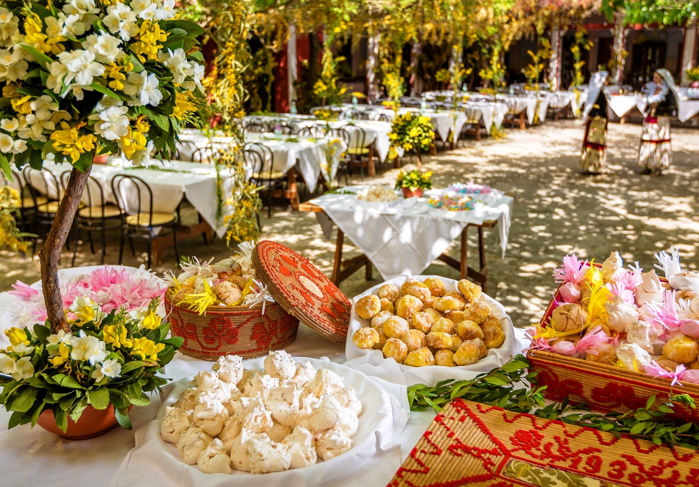
The sweet flavours of the festive season
The typical breads and cakes prepared in Sardinia for Christmas have always been a symbol of festivities and celebrations, and are richly flavoured jewels, always different from one village to another. In the Logudoro bakeries, su bacchiddu 'e Deu, a stick-shaped bread reminiscent of a bishops' crosier, and sa pertusitta, a flatbread decorated with relief images of shepherds and sheep, are prepared. The taste of sa tunda, a round bread from Oristano, is enriched with walnuts and sultanas. In Ogliastra, there used to be an ancient custom that returns every now and then: gifting loaves of bread in the shape of a heart, a star or a baby. Originally from the Nuoro area, nowadays baked all over the island, is su pani cun gherda, i.e. with pork crackling. There is a cake that was once only for Christmas but is now so good that for decades it has been prepared all year round: torrone di Tonara (nougat). It has no sugar, just a base of honey melted over a low heat in a copper pot and stirred for hours, with the addition of almonds, hazelnuts or walnuts.
Waterfalls of pure water
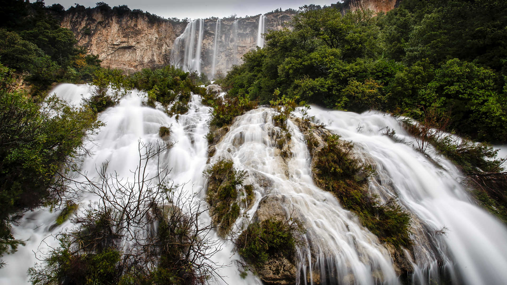
On an island of ancient volcanoes, Montiferru was the largest. Today it is an immense basalt plateau furrowed by rushing waters, which on the border between Bonarcado and Santu Lussurgiu give way to the enchanting waterfall of sos Molinos. Underground currents rise to the surface in the hamlet of San Leonardo, within the forest of the same name, with the purest and most mineral-rich springs of Siete Fuentes. The waters of Montiferru also feed the Salighes stream, a quiet torrent that is the star of a phenomenon like no other in the world: it plunges directly into the sea from the cliffs of Cuglieri. The waterfall is called s'Istrampu de Capu Nieddu, a thunderous 40-metre drop that is even more impressive when heard from the sea. Further south, in the Medio Campidano, there is Mount Linas with the oldest rocks in Europe, a primordial land with few signs of human interference and populated by deer, foxes and wild boar. The peace of its forests is disturbed by the roar of three grandiose waterfalls: sa Spendula cuts through the forest like a blade, in the words of D'Annunzio, Piscina Irgas plunges 45 metres into a distinctive emerald-green lake and Muru Mannu, one of the highest in Sardinia, surrounded by a scenic amphitheatre
Capo Figari and Figarolo island
It is a natural open-air museum that embellishes the coast of Golfo Aranci, in Gallura. The promontory of Capo Figari, along with the islet of Figarolo in front of it, have been declared a Site of Community Importance and are treasure troves of biodiversity. You can get to the promontory via the beach of Cala Moresca, a ‘gem’ set in a little bay and cooled by a pine forest. The summit of the promontory is just over three kilometres from the cove and, at the top, at a height of 350 metres, are the remains of the Naval Semaphore, inaugurated in 1890, purchased by the Ministry of Defence 15 years later and made famous in 1932 by Guglielmo Marconi, who built a shortwave radio link there, connecting it to the transmitter in Rocca di Papa, near Rome. From up here, you can enjoy a breathtaking view: to the south, you can see the entire gulf of Olbia, with Capo Ceraso and the island of Tavolara, while to the north, you can see the islands of Soffi and Mortorio with the Costa Smeralda in the background.
Various trekking trails are marked out on the promontory, thanks to which you can observe other pieces of historical evidence that underline the importance and the use of the site over the years. Behind Cala Moresca, there is a furnace for the production of lime, which was abandoned after just a few years of use. Moving on along the Filasca trail, you will come to the Luigi Serra coastal battery, built during the First World War on the peak that gives the trail its name. You will notice the remains of turrets and circular bases on which the cannons were anchored. A detour will take you to a small cemetery, called ‘of the English’, in honour of the burial of an English sailor, accompanied by a Celtic cross, though in reality, it is mainly the burial place of Italian sailors who disappeared during various shipwrecks. Going beyond, you will reach the picturesque Cala Greca, with its deep waters that give the sea a strong blue colour. Nearby, you will notice the unusual rock of Mamma Chiatta, a name given to it by the fishermen of Golfo Aranci because of the outline that, according to them, resembles an overweight elderly lady. The northern side of the promontory will treat you to other captivating views of places that can be reached by sea, like Cala del Sonno and Cala Fenice.
In front of Cala Moresca, Figarolo appears. Its name comes from the presence of flourishing fig trees. The island is a limestone plateau with an unusual pyramid-like shape. A variety of wildlife resides there: moufflons, cormorants and buzzards. The raven also passes through and sometimes the peregrine falcon nests there. The vegetation includes holm oaks, lentisk trees and thousand-year-old olive trees. The surrounding seabed is a paradise for diving enthusiasts: shallows, underwater caves, black corals and also groupers, lobsters, corbs, sea urchins, sponges and sea fans. Off the island, lies the small wreck of a merchant ship that sank in the mid-20th century.
Lu Brandali
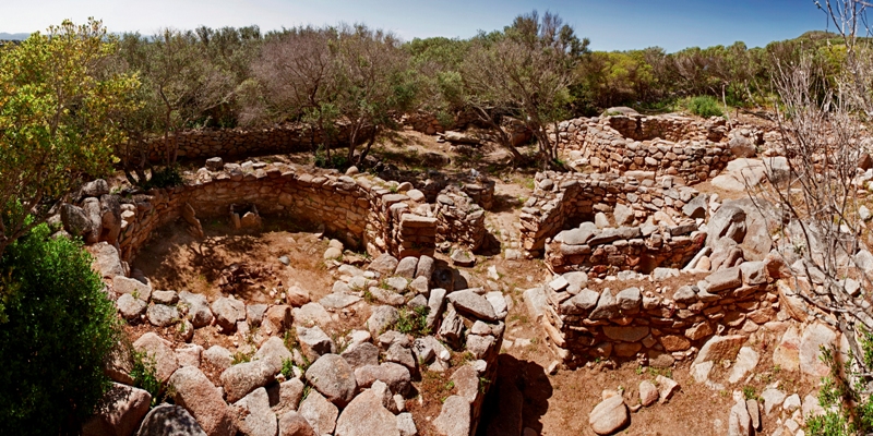
A short distance from the sea, on a granite promontory in Santa Teresa Gallura, the Nuragic civilisation has left some of its most fascinating traces, revealing its intimate daily and spiritual aspects. In the archaeological complex of di Lu Brandali you will travel through time, amidst the houses, ‘workshops’, defensive and funeral buildings of a past that dates back to between the 14th and 10th century BC. The evidence of a distant past stretches along the slopes of the promontory, surrounded by lush Mediterranean scrub. On the top, stretching over staggered levels to take advantage of the rocky formation, stands a nuraghe featuring mixed architectural elements, both ‘corridor-type’ and ‘ tholos-type’: it has a keep surrounded by a secondary defence wall with two towers, one of which was used as a furnace in the centuries that followed.
Close to the fortified area, along the slope and on the plain south-east of the nuraghe, you will visit the remains of the village. The huts, generally with a curvilinear layout, also took advantage of the landform. The walls were made of blocks positioned using the row technique and connected by mud mortar, while the floors were made of rammed earth and, in some cases, there were also rock benches. You will notice the traces of different superimposed walls: the rooms were subjected to restructuring and reorganisation of the spaces, with the addition of rooms used as artisan ‘workshops’. The huts, often built in small clusters and separated by narrow corridors, were not the only type of housing solution: to the west you will, in fact, come to the area of the tafoni, which contribute to the charm of Lu Brandali. A passage between the rocks leads to a group of granite caves, used by the villagers both as shelters and for burials.
A few dozen metres from the site, in the portion of the complex further downstream, there is a Tomb of Giants: you can guess how majestic it must have once been from the size of the still visible foundations. The tomb corridor is more than six metres long and ends in an apse shape, the flooring is made of flat slabs in front of the entrance to the exedra and in cobblestone in the remaining space, while two jambs, on which an architrave originally rested, delimit the entrance. Here, thousands of years ago, occult and mysterious ceremonies took place, in which worshippers and priests ate ritual meals and smashed ceramic containers on the ground, as shown by the numerous finds unearthed during the excavations.
After a visit to the daily life of the past, the magnificent sea of Santa Teresa awaits you: moving towards the promontory-peninsula of Capo Testa you will come across the splendid beaches of Rena di Ponente and Rena di Levante; in the western part of the cape, you cannot miss the charm of Cala Grande-Valle della Luna. A short distance from the main village square is the bay of Rena Bianca, a city beach with soft, very white sand, with the imposing Tower of Longonsardo watching over it from above. The tower was built in the 16th century by order of King Philip II and protected against pirate raids. Today it is a symbol of the town and a captivating location where you can admire the spectacular sunsets.
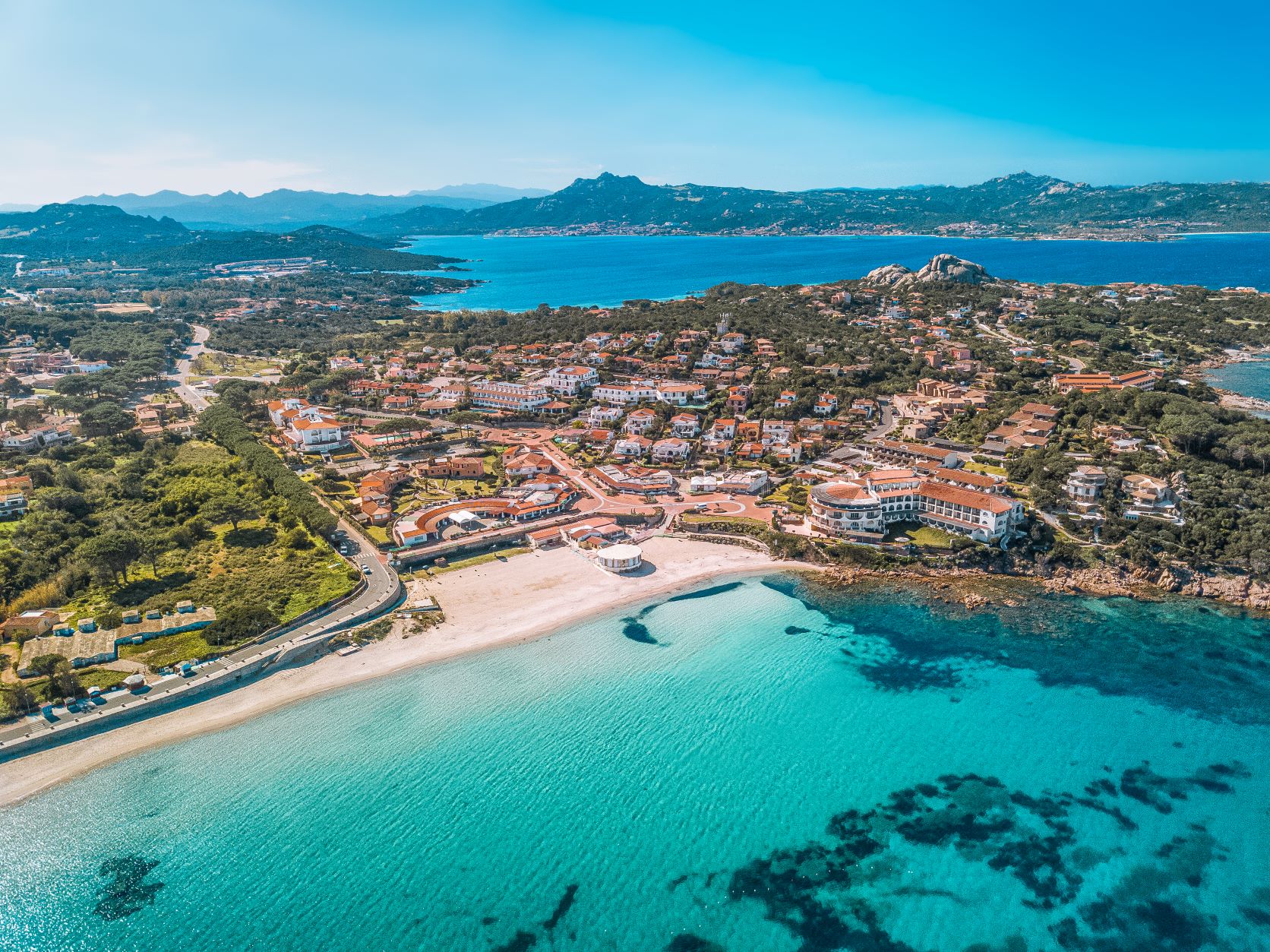
Baja Sardinia
A dream vacation filled with relaxation, fun and social life. Baja Sardinia, built a few years after the tourist boom that took place on the Costa Smeralda at the initiative of Italian entrepreneurs, is one of the most famous seaside resorts on the island. It has high quality services and the most modern accommodation facilities for all tastes and pockets, a stone’s throw from well-equipped beaches. The little tourist village, in the Arzachena area, just four kilometres from the well-known Porto Cervo, gives its name to the entire resort, which has become a reference point for hikers and for diving, windsurfing and canoeing enthusiasts.
If you want to enjoy the natural beauty in complete tranquillity and enjoy a dip in the blue sea, you will find what you are looking for here, on a visit to Cala Battistoni, a beach of fine sand, surrounded by a crystal-clear sea. From the tourist village, you can get to other attractions that the bay has to offer, starting from Cala Granu, until you reach Cannigione or Poltu Quatu. However, if you prefer wilder nature, a trip to the islands of Caprera and La Maddalena is a must, as well as the other smaller islands in the Archipelago National Park.
Baja Sardinia has modern facilities for all kinds of fun, starting from water sports and canoeing. Services for boat trips, windsurfing and scuba-diving are offered all along the coast, where you can also rent boats for ‘do-it-yourself’ tours. There is no shortage of services and sports fields for sports enthusiasts, while youngsters can spend hours of fun in the water parks. When the sun goes down, if you want to try some typical seafood dishes, you’ll be spoiled for choice thanks to the numerous restaurants in the area, and you can finish off your evenings enjoying the Costa Smeralda nightlife, in the renowned clubs, bars and discopubs.

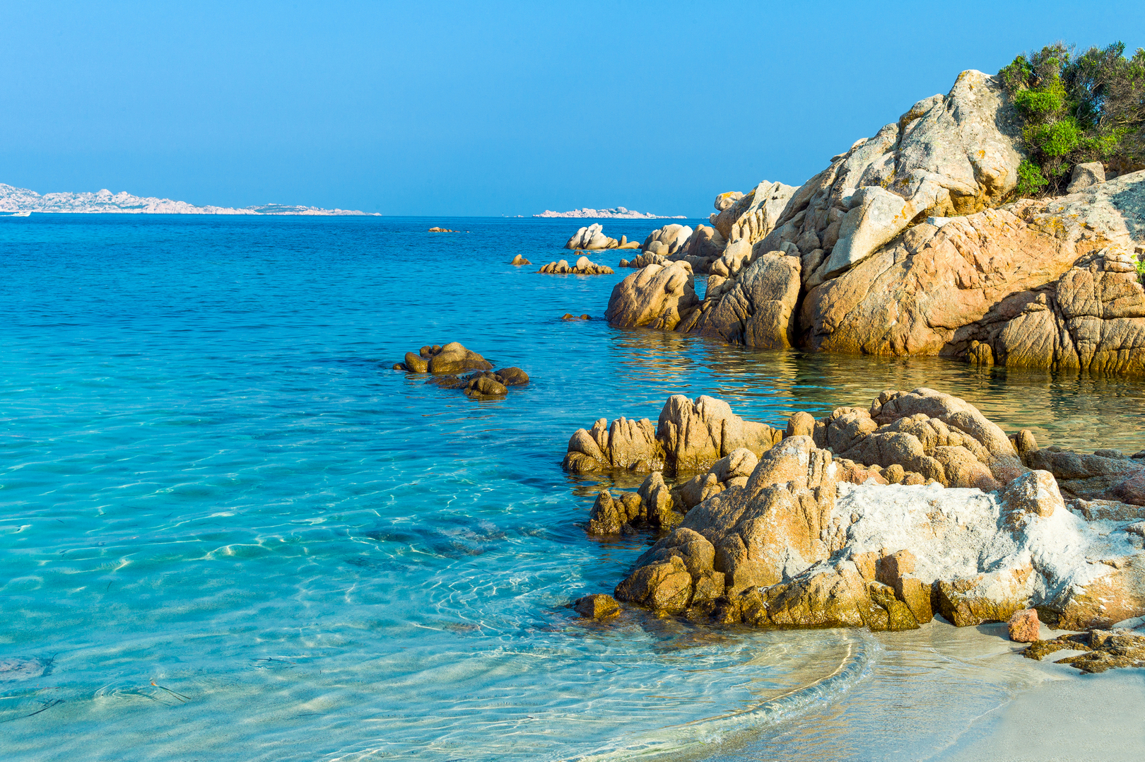
Cala del Sonno
Cala del Sonno is easy to get to from the sea and from the land along an arduous dirt path accessible from the northern territory of Golfo Aranci, in the eastern part of Gallura, and is a delightful cove on the promontory of Capo Figari, known for its unspoilt natural landscapes. The bay is surrounded by legends handed down over time and, in the past, fishermen would land on the small beach to find shelter and rest during the night.
The bay is made up of pebbles and bathed by waters reflecting shades of turquoise and emerald green, while the seabed is rocky and characterised by underwater caves. This is one of the reasons why it is an ideal destination for diving and snorkelling lovers, although, due to the arduous landscape, it is not equipped with bathing services. The surrounding nature, dominated by Mediterranean scrub and junipers, also offers trekking enthusiasts impressive nature trails along the rugged coastline that reaches the promontory of Punta d’India.
The promontory of Capo Figari, dominated by an ancient lighthouse, 350 metres above sea level and overlooking the islet of Figarolo, is also a nature reserve and a unique habitat in the Mediterranean, waiting to be discovered with trekking itineraries. You will reach it after visiting other splendid bays of Golfo Aranci, Cala Moresca and Cala Greca. Near the beaches, you will find accommodation facilities that also organise boat trips, particularly in the Marine Protected Area of Tavolara – Capo Coda Cavallo.
Cala di Volpe
Lush Mediterranean vegetation stretches for kilometres in the bay of Cala di Volpe, in the territory of Arzachena, where myrtle hedges and enchanting juniper thickets look out to sea, bending in the northwesterly wind. It is one of the most famous locations for luxury tourism but it offers a wide choice of accommodation for all types of holiday-makers.
The inlet contains four splendid beaches: Cala di Volpe, as well as Liscia Ruja, Petra Bianca and Petra Niedda. The beaches are small and have medium-grained sand, typical of this splendid part of the Island. The waters are shallow and the seabed slopes gently out towards the open sea, with its transparent rich blue waters. Granite rocks emerge from the waves, making the coastal landscape even more distinctive.
The heart of the bay is the tourist village overlooking the sea, thanks to a small port, an ideal landing place for various types of boats, especially large yachts. From here, you can set off on guided tours by sea or, from May to September, you can take advantage of the taxi boat service, deep sea fishing and boat, dinghy and Jet Ski rentals. All around, you’ll find every category of accommodation, including some of the most luxurious hotels in the whole of Sardinia.
The strategic position of the bay offers easy access to other famous beaches of the Costa Smeralda such as that of Il Principe (Prince’s Beach), Romazzino, Li Ittricceddi, Grande Pevero and Piccolo Pevero. Right behind the village, you’ll find one of the most famous golf courses on the Island and in Europe. Designed in 1972, it offers a splendid view of the entire bay, with its putting greens stretching to the sea.

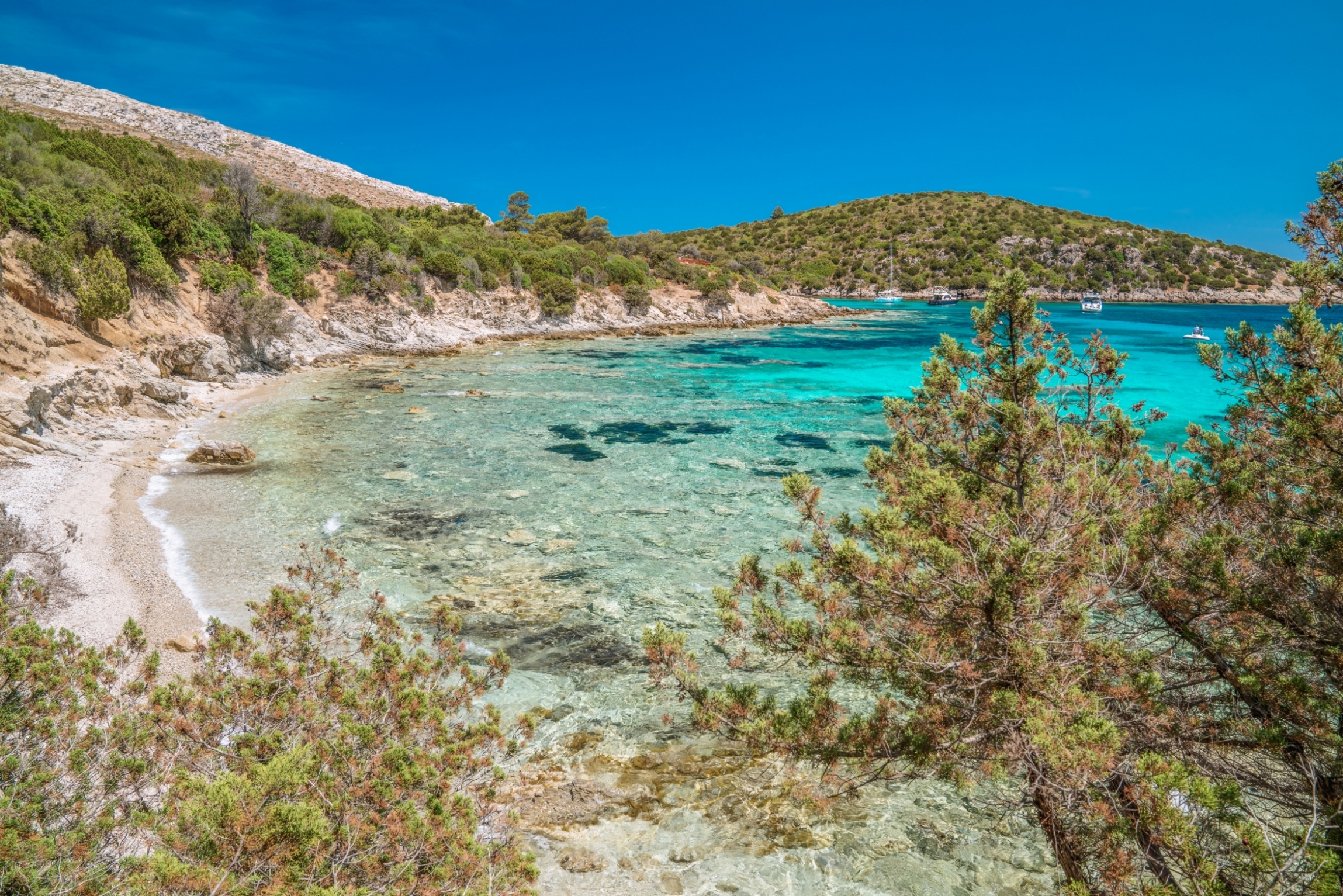
Cala Francese - La Maddalena
Coastal granite quarries were a significant part of the history of the Maddalena Archipelago, where granite mining began in the 19th century and it was exported to many parts of the world. They are found particularly on the beaches of the western part of its largest island. The most shining example is the pink and white granite quarry of Cala Francese, active until the Second World War and now open to the public: you can admire via ferratas, old machinery, a train and cranes. Located to the south of the promontories of Punta Carlotto - known for its military battery - and Punta Testiccioli, the large inlet of Cala Francese forms various small rocky beaches and can be reached along the road that leads to the fortification. Particularly in its southernmost part, there is a small beach made up of light, medium-grained sand, embellished with smooth pebbles.
It is delimited by two cliffs, which protect it from the winds. The seabed is mainly sandy and the water rapidly becomes deep near the shore. The typical granite rock around it, covered with thick Mediterranean scrub, makes it one of the pearls of La Maddalena, the entire coastal perimeter of which will enchant you with 45 kilometres of cliffs, inlets and coves. To the south of Cala Francese, you’ll find the shining colours of Punta Tegge and the captivating Nido d’Aquila. To the north, you’ll find rocks shaped by the wind and beaches of white sand dunes like Bassa Trinita, fine sand surrounded by granite rocks, and then Cala Lunga and Monti d’Arena. To the east, not far beyond the isthmus that connects La Maddalena to Caprera, where there are multiple natural and cultural attractions, you will find the delightful scenery of Spalmatore. You can also set out from La Maddalena, to discover the other islands of the national park: Santo Stefano, Budelli (with the famous Spiaggia Rosa or Pink Beach), Razzoli, Santa Maria and Spargi.
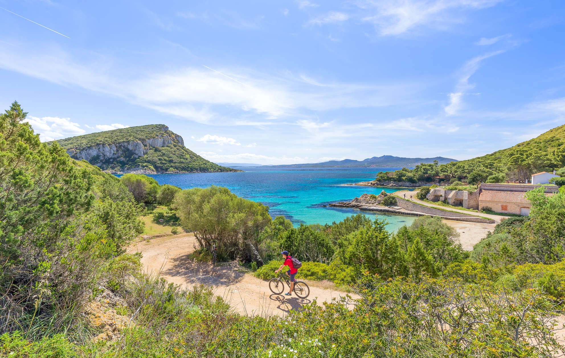
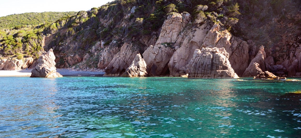
Cala Moresca - Golfo Aranci
Cala Moresca, a small inlet with two little beaches of fine, golden sand contrasting with the emerald green sea, is located inside the protected area of the promontory of Capo Figari. It falls within the territory of the residential area of Golfo Aranci – just over two kilometres away - and it is about twenty kilometres from Olbia.
The strips of sand are interspersed with rock formations emerging from the water and looking out at the island of Figarolo, which stands out with its distinctive pyramid shape. It is an uncontaminated bay of great natural value: to reach it, you will have to leave your car in a special car park a few hundred metres from the shore. A pine forest, behind Cala Moresca, provides shelter during the hottest hours and the dense vegetation of the Mediterranean scrub hides a path, between cliffs and rocks, that connects to other beaches on the promontory: Cala Greca and Cala del Sonno.
Near the beach there are hotels, also organised for boat trips, particularly in the marine protected area of Tavolara – Capo Coda Cavallo, or excursions by land on the high ground of Capo Figari, dominated by an ancient lighthouse.
Walking along the paths through the pine forest, you will come to an industrial archaeology site, featuring the remains of a kiln once used for the production of lime. Its history bears witness to the intense mining activity that took place in Capo Figari from the Middle Ages until the second half of the 19th century.
Cala Li Tinnari
A magnificent oasis of peace and relaxation, full of charm and colours, little frequented even in the summer. Li Tinnari is a solitary cove surrounded by jagged rocks and Mediterranean fragrances along the spectacular stretch of sea between Costa Paradiso and Isola Rossa, at the extreme western boundary of Gallura, on the Anglona border. The two well-known tourist villages fall within the territory of Trinità d’Agultu and Vignola, a municipality formed by the union of two localities, the first inland and the second on the coast. The beach has light, almost golden sand, together with smooth little pebbles. They are mostly grey and white, carried there by the Riu Pirastru that flows behind it and forms a pond, hence the beach’s second name of Lo Stagnone (meaning big pond). They are partly reddish, originating from the granite cliffs that surround the cove.
The appearance of the beach is that of an expanse tinged with grey, washed by a crystal-clear sea with shades of emerald green turning into light blue and deeper blue as you go further out to sea. On a predominantly rocky seabed, patches of sand appear near the shore and rocks shaped by water and wind emerge. The largest of them stands in the centre of the beach, dividing the beach into two semicircles that, when seen from above, create a ‘heart’ shape, a famous and distinctive image of Sardinia.
Entering the cove is not simple, nor immediate. There are three ways to get to it: by sea, independently or by organised tours, and there are two itineraries by land. One is short, consisting of a twenty-minute walk after parking in the parking area at the end of the diversion towards the sea (five kilometres) of provincial road SP 90, which connects Castelsardo to Santa Teresa Gallura. From the car park, you can get to the beach at the end of a one-kilometre path across the slopes of Mount Tinnari, the peak of which (214 metres) dominates the Gulf of Asinara. The second route starts at Li Cossi, an enchanting, sheltered cove of fine, very light sand washed by a multicoloured sea, surrounded by imposing pink cliffs. A seven-and-a-half-kilometre dirt path - a round trip of about two hours - divides the two ‘pearls’ of Costa Paradiso. The path is long but not demanding and it isn’t signposted, yet it’s easy to follow. Some stretches are very short ‘tastes’ of trekking, to be tackled with caution: the reward is in the wild and disarmingly beautiful landscapes, like the stretch next to the secluded pink, pebbly coves of Porto Leccio. With uphill and downhill sections, the path largely follows the coastline, between rocks and expanses of quartz, covered with junipers, mastics, cistus and helichrysum. At times, the Mediterranean scrub thickens so much that the path becomes a shady corridor.
Trinità d'Agultu, the municipal ‘capital’, stands 350 metres above sea level, dominating the coast, a granite landscape, interspersed with coves and beaches of soft, white sand. Vignola contains the two seaside villages of Costa Paradiso and Isola Rossa, so called because of the colour of the islet in front of it. Here, you’ll find the dazzling beach of Longa and, without interruption, La Marinedda, with its light, white sand, washed by the light green crystal-clear waters. It is a destination for windsurfing enthusiasts. Its spectacular dunes are closed to the south by Punta Li Canneddi, where Cala Canneddi, another stretch of fine, light sand opens up. Nearby, there are other breathtaking coves, like Cala Rossa, set in a magnificent natural environment, and the solitary Li Feruli, with its cream-coloured sand. Further south, you come to the coast of Badesi: among the various coastal treasures, you’ll find Li Mindi and Baia delle Mimose.