
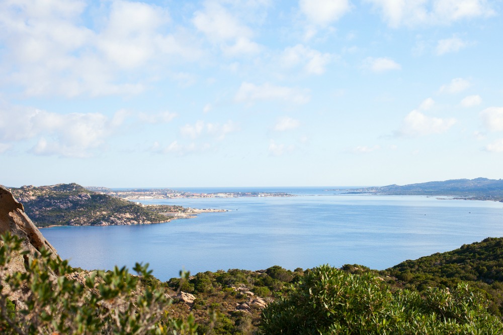
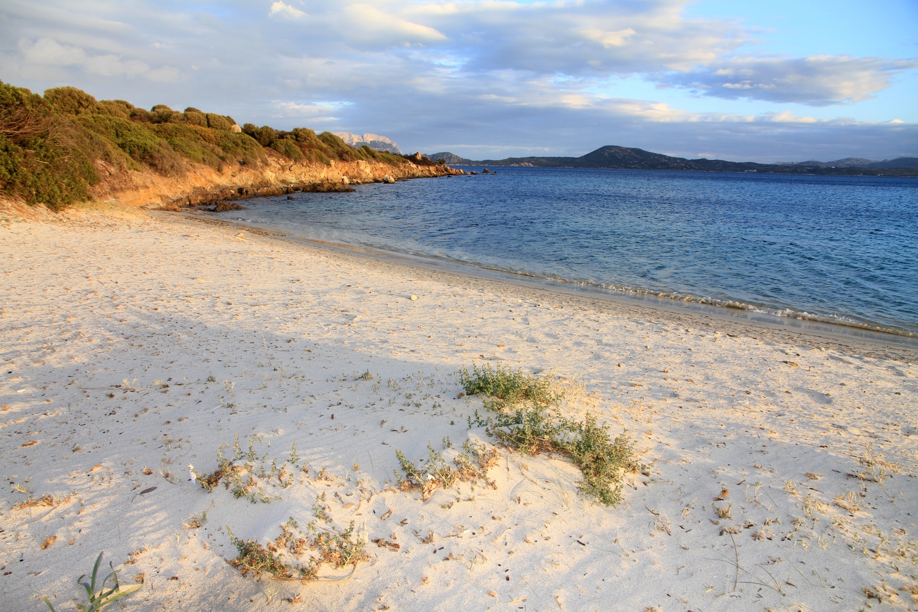
La Maddalena
A road runs all around the perimeter: 45 kilometres of breath-taking panoramas. Granite and porphyry mark out jagged areas, coves, inlets and beaches, while the interior is made of gentle hills. La Maddalena lends its name to the whole archipelago, of which it is the largest island, and the national park of which it is the administrative centre.
It was a military naval base for many years, as witnessed by the Nino Lamboglia naval museum. Its strategic position in the Mediterranean has marked its history: in 1793 the French army led by a young Corsican officer, Napoleon Bonaparte, tried to invade, but was held back by the fleet commanded by Maddalena-born Domenico Millelire. Among others, the island also attracted the attention of Admiral Nelson. Today it captures the holiday dreams of lovers of natural scenery and extraordinary beauty.
The town is the only one in the archipelago: La Maddalena, founded in 1770, faces Palau, a 20 minute ferry ride away. The stone-paved alleyways of the centre open onto 18th century buildings, including the town hall and the Santa Maria Maddalena parish. The small harbour of CalaGavetta has a statue of Giuseppe Garibaldi, who lived out his last 26 years in Caprera, linked to La Maddalena by the Passodella Moneta, and famous for the Compendio Museale Garibaldino.
You can admire the suggestive scenery along the road to Spalmatore, a delightful cove.Three kilometres from the centre is the Cala Francese inlet: between the Mediterranean brush and the granite quarry, you can discover tranquil inlets and incredible beaches. In the south, along the Padule se road, you reach the Nido d'Aquila, near the military fort. Not far off is another spectacle, Punta Tegge. To the north, beyond the Strangolato isthmus, are coves of white dunes surrounded by wind-sculpted rocks and beaches: don't miss Bassa Trinità, CalaLunga and Monti d'Arena.
Set out from La Maddalena to explore the other islands in the park: Santo Stefano to the south, Budelli and the famous Spiaggia Rosa, Razzoli, Santa Maria and Spargi to the north.
Rena Majori
Beyond a shady pine forest, walking through dense juniper bushes, you'll come upon the brightly coloured countryside of Rena Majori, a strip of white, incredibly find sand that slips into an enchanting coloured sea, bordered by dark rocks and light granite. In the area of almost the same name, Rena Majore, in the territory of Aglientu, is part of the natural site of Monti Russu.
The sea, made of light and dark brush marks of blue, acts as a "magnet" for children with its rocks and small pools. As well as having a gently sloping gradient perfect for less expert swimmers, the sea bed at Rena Majori, with its bright colours and full of fish, is a favourite with divers and snorkelers.
The coastline is broken by the mouths of the Rio Cantaru and the RiuoCiuchesa, which "cut" the strip of sand into three parts, making the shore even more suggestive. It is rarely crowded and has been used for several advertising campaigns, including one with Australian actress and model Megan Gale. Behind the beach, a vast pine forest shelters you from the wind and offers a relaxing refuge on hot days. For the more romantic, don't miss a long walk on the beach during a spectacular sunsets. A large car park, campsites and beach equipment for hire complete the scene.
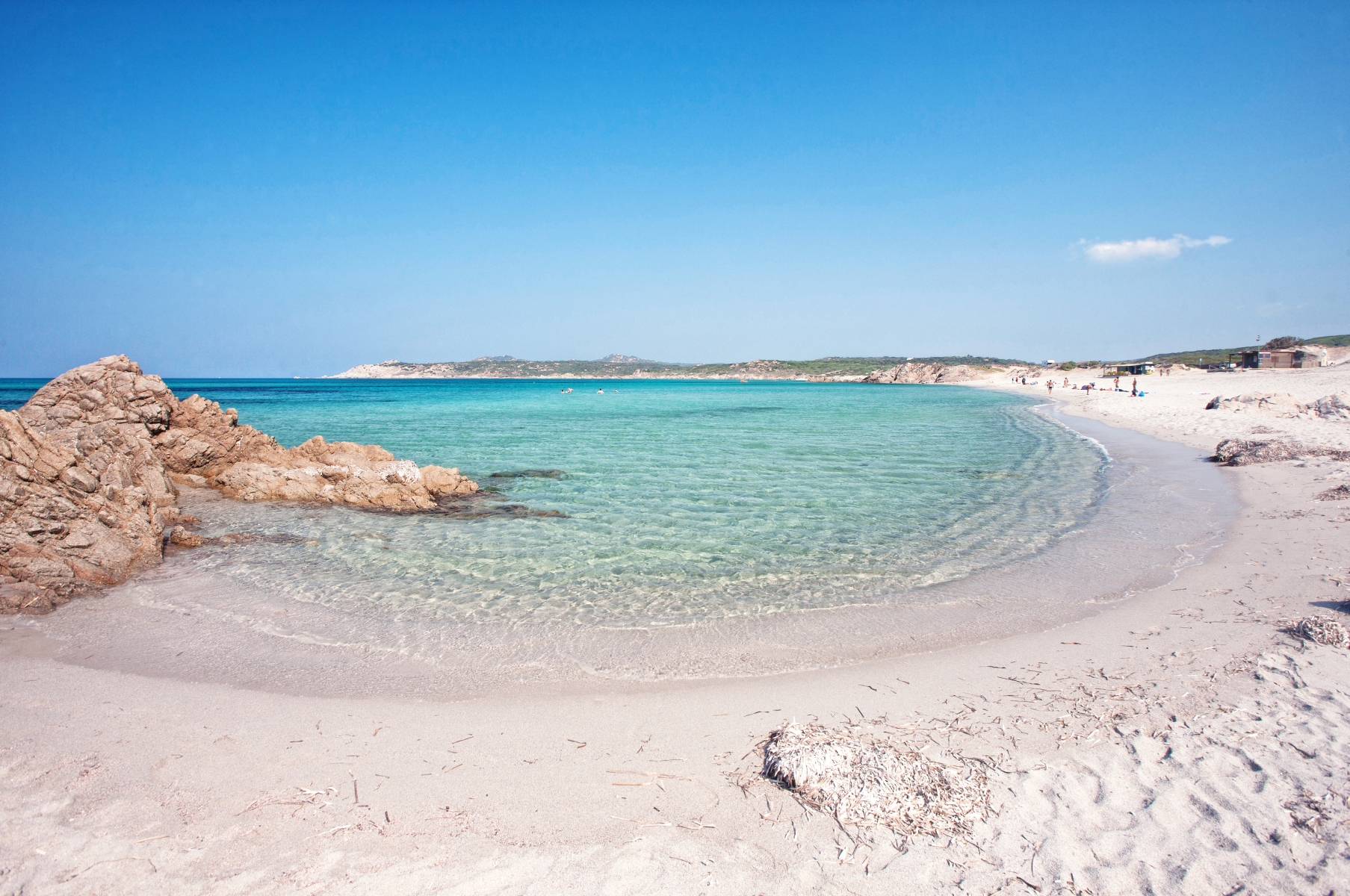
Rena Majori is only eight kilometres from Santa Teresa Gallura and its "town" paradise Rena Bianca, a 700 metre cove with shallow water and soft, white sand, a clear sea with stunning colours. On the way out of town, before arriving at Rena Majore, you'll come to the peninsula-promontory of Capo Testa, joined to the mainland by a strip of sand that forms two beaches - Rena di Ponente (or Taltana) and Rena di Levante - and the spectacular Valle della Luna and Cala Grande. Continuing along the shore towards Aglientu, you'll find the rocky coves of Santa Reparata and the enchanting Lu Pultiddolu.
Capo Coda Cavallo
One of the symbols of Sardinia. Capo Coda Cavallo is a strip of granitic land that extends into a stretch of sea sheltered by the impressive mass of Tavolara, with the smooth rocks of Molara and the picturesque islet of Proratora, which together form a protected area covering 15,000 hectares of crystal clear water, coves and inlets, from Capo Ceraso to Punta s'Isuledda, where the southernmost of the splendid San Teodoro beaches lies.
It looks like one of the most suggestive coastal landscapes of the Mediterranean: white, sandy beaches, islets, lagunas and infinite shades of colour. However windy it is, you'll find the sea calm here. And underwater, there is a whole new world to discover.
The Tavolara-Capo Coda Cavallo marine area is ideal for diving, with tried and tested itineraries, crevasses and caves, habitats rich in biodiversity and populated by shoals of confident fish that, among the red starfish and yellow gorgonians, offer an unforgettable spectacle, such as at TedjaLiscia and in the Secca del Papa shallows, southeast of Tavolara at Punta Arresto, in the island of Molara and on the sea bed around the Molarotto rock. The peninsula is characterised by sandy inlets covered in strongly scented Mediterranean brush: arbutus, junipers, mastic, myrtle and tamarisks. The beach at Coda Cavallo has a particular shape, from which the promontory takes its name: the sea here is so sheltered that is seems like a calm, limpid laguna.
Some of the most famous beaches of San Teodoro (and the whole of eastern Sardinia) are only a few kilometres from here:Salinedda Bay, with sand and red rocks, sheltered by Ruja island, Cala Brandinchi, with its dunes of fine, white sand and crystalline sea bed, and its "twin" Lu Impostu, a curve of white sand and clear water that arches over nearly a kilometre. Then there is the delightful Cala Suaraccia (or the butterfly beach), the fascinating shapes of the rocks at the coves of CalaGhjlgolu, which you can reach from paths through ancient junipers, and the most famous, La Cinta, with its three kilometres of find sand dunes, that end to the north with the splendid promontory of Puntaldìa. Behind the dunes is the Laguna di San Teodoro, a stopover point for pink flamingos during migratory periods and home to black-winged stilts, an ideal place for a walk and some birdwatching.
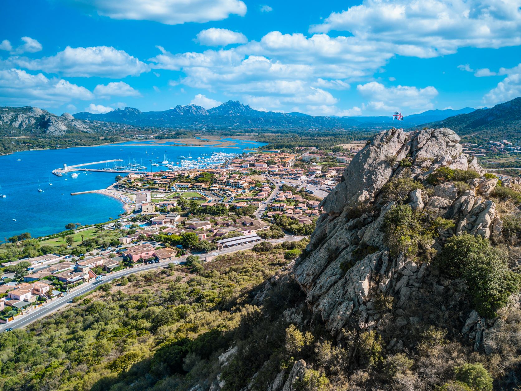
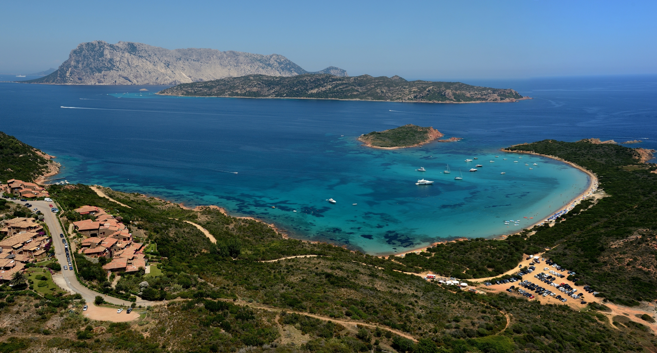
Cannigione
It is located on the western side of the largest and deepest ria, that is an inlet created by a river mouth, in the northeastern part of Sardinia. Cannigione, a district of Arzachena, originally a fishing village, is a renowned tourist village. Its promenade is made up of the docks of a large, modern port. Next to it, is the 'city' beach: light, large grained sand leading into the sea with its infinite shades of blue. The seabed slopes gently and is very popular with those who like scuba diving and snorkelling. In fact, it has become one of Sardinia's diving centres par excellence: the banks of seagrass in various diving areas should not be missed, particularly at the Scoglio di Mortoriotto. Near the sandy shore there is also a car park, equipment and boat rentals, bar, restaurant and accommodation facilities.
Near the village, there are many other beaches, from the Gulf of Arzachena to the Salt Pans of Palau: La Conca, Tanca Manna, Mannena, Barca Bruciata and Isuledda. The shoreline is ideal for young families and provides you the possibility to choose nearby, exclusive locations every day: Porto Cervo, Baia Sardinia, Poltu Quatu. Along the 55 kilometres of Arzachena coastline, don't miss out on a visit to the little coves of Lu Multiccioni and Li Capanni, the long beach of Tanca Manna and the Caribbean feel of Cala Capriccioli.
Arzachena, less than ten kilometres from the village, embodies the style of the Costa Smeralda: pink granite and white stones characterize the architecture of the houses. There are green spaces, establishments, clubs and boutiques everywhere. The typical artisan products and Sardinian delicacies combine with luxury shopping. Boat trips depart from Cannigione and head to the Maddalena Archipelago National Park. To the south, there is the Stagno di Padula Saloni, a pond area in which, between the reeds, rushes and tamarisks, bird species nest, including the purple heron, the black stork, the osprey and the western swamphen, a species that lives exclusively in the island's lagoons. Also populating the brackish waters are coots, moorhens, egrets, mallards and sometimes the greater flamingo. The bushes in the pond area have a reddish colour in the summer, creating extraordinary scenic effects at sunrise and sunset. To the north of the village stands Punta Occhione, covered by a carpet of Mediterranean scrub: from the top you will enjoy the view over the entire gulf, as far as the Roccia dell'Orso (Bear Rock).
La Playa - Pittulongu
This is the favourite beach of the inhabitants of Olbia, about eight kilometres from the town, on the road that leads to Golfo Aranci. Famous also as Puntale Lungo, La Playa di Pittulongu is a splendid and extensive ‘half-moon’ of very fine, white sand with a few stretches of small shells, especially near the water's edge, set between Punta Muriscinu and Punta Filiu. The water is shallow, with a sloping seabed, and it is perfect for families with children. On the sandy shore, there are beach establishments that offer you all the most useful services: facilities that can be accessed by the disabled, ample parking and beach equipment, pedalo and boat rentals. There are characteristic bars and restaurants with a view of the impressive island of Tavolara, overlooking the beach, highly frequented by windsurfing, diving and snorkelling enthusiasts.
La Playa is the first and most highly frequented beach in the Lido di Pittulongu. Next to it, there is the beach of Lo Squalo (Shark), separated by a small rocky strip of land. Further on, you will find Il Pellicano (Pelican), an expanse of sand very similar to La Playa but much smaller and with little rocks that emerge. Further ahead, still on foot, you will reach Mare e Rocce, with its fine, light sand. Further north, on the border, there is Bados, a vast sandy shore with soft grey-ochre coloured sand.
The coast of Olbia also includes other long stretches. To the north, in the direction of the Costa Smeralda, there are numerous ‘pearls’ with white sand (or little pebbles) and the crystal clear sea at La Marinella, at Porto Rotondo, at Marina di Cugnana and at Portisco, among which Sa Rena Bianca. To the south, along scenic state road no. 125, in the direction of San Teodoro, you will find, in sequence, the beaches with yellow-ochre coloured sand of Lido del Sole, Le Saline, Bunthe and Li Cuncheddi, the four splendid coves of Porto Istana, which are part of the protected area of Capo Coda Cavallo, and lastly Punta Corallina, on the border of Loiri Porto San Paolo.

La Sciumara - Rada di Mezzo Schifo
Not even a landscape painter would have been able to use this many colours: from the green of the holm oak forest behind it to the cream colour of the sand, the many shades of blue of the sea and the silver reflections of the granite rocks. The beach of the Sciumara is a colourful crescent shape on the Palau coastline and can be reached on foot and by bike from the residential area. The name - which means ‘mouth’ in Gallura dialect - comes from the fact that the Surrau river flows to the sandy shore.
The beach is bordered to the east by Punta Acapulco and to the west by the Baia di Nelson. Its sand is medium-large grained, the seabed is sandy and the water is shallow, making the beach suitable for families with children. It is particularly popular with snorkelling enthusiasts, thanks to its transparent waters and rich fish fauna.
The view is embellished by the islands of La Maddalena and Santo Stefano, integral parts of the Archipelago di Maddalena National Park, which stand out respectively in front of and to the right of the beach. At La Sciumara, you will find a large car park, refreshment areas and the possibility of renting umbrellas and boats. The shore is also accessible to disabled people. In late spring, the beach becomes a location for exciting windsurfing competitions, thanks to the constant winds. The bay overlooking the beach is also called Rada di Mezzo Schifo: the name probably comes from the presence of half a hull - schifo in the dialect of La Maddalena - of a wreckage in the waters in front of the beach.
On the subject of beaches, in Palau you will be spoilt for choice: to the east, beyond Punta Acapulco, there is the unmistakable outline of the white lighthouse with a green tip characterising the beach of Porto Faro. Moving on, near the rails on which one of the routes of the Trenino Verde tourist train runs, you’ll find the beach ‘most loved’ by the people of Palau: Palau Vecchio, with its charming old-fashioned atmosphere. Next to the tourist port you will find the beach of Isolotto, bordered by the pine forest of Punta Nera. To the west of Sciumara lies the ‘historic’ beach of Nelson, an oasis of tranquillity and shelter, the picturesque village of Porto Rafael with its little white houses and the wild and unspoilt scenery of Cala Trana. The most original picture postcard landscape is located even further west, where a strip of sand connects the coastline to s’Isuledda, also known as Isola dei Gabbiani (Island of Seagulls). There are two beaches on each side of the isthmus: Porto Pollo on the right and Arenaria on the left: each one is a paradise for kitesurfing and windsurfing.

Buddusò
Rising 750 metres above sea level in the southern part of the homonymous plateau, Buddusò is in the Monte Acuto. The village perhaps derives its name from the moniker biddisò (sparrow), after having been initially known as Gullusò from the 14th century. Its territory, most famous for its white granite quarries, is covered with pastures, cork oaks and dense Mediterranean scrub. It is traversed by the Rio Mannu which runs into the Lago di Coghinas and the Rio Altana that flows into the Tyrrhenian Sea. The territory, which regularly hosts special stages of the world Rally Italia Sardegna, was inhabited as of the Neolithic period, as is evidenced by a dozen Domus de Janas within the town and over 50 collections in necropolis, scattered throughout the countryside. The most famous are the Domus de Borucca and the necropolis of Ludurru, 200 metres from the village, with hypogaea excavated in a single granite outcrop.
The successive period is abundantly ‘recounted’ by 32 nuraghe. Some of the complexes are well preserved, in all the Loelle nuraghe, located seven kilometres from the village and comprised of worked blocks, bearing a trefoil shape steps and corridors running over two internal floors. Characteristic is an underground chamber (perhaps a cellar), whilst the tower played the role of overseeing a village. Alongside are two small Giants' tombs. Also noteworthy is the village of Sos Muros, which retains an intact well. 15 kilometres from Buddusò, in the bordering territory of Bitti, sits one of the most important nuraghe complexes of all, the village-sanctuary Su Romanzesu. During the Roman age, the Buddusò area was the site of a station on the Karalis road - the Forum Traiani-Olbia. There are still traces of the inhabited area of Caput Tyrsi near the springs of the Tirso river. The Iberian domination, on the other hand, is evident in Buddusò from the baroque church of San Quirico. The other main churches are the parish church of Santa Anastasia and the rural one of Santa Reparata, celebrated with a festival in early September.
The town, with almost four thousand inhabitants, witnessed an economic development in the last few decades of the 20th century thanks to the extraction and processing of cork and granite, used all over the world. Clearly, this is also the material used to construct the traditional houses. Many statues are to be seen around the town and in the modern art museum, built in the twenty-year period from 1980 to 2000, during the sessions of the International Wood and Granite Symposium, in which artists from all over the world competed throughout the streets and in the piazzas, in the shaping of granite and wood. In the historic centre, Villa Doneddu in neo-Gothic style can also be admired.
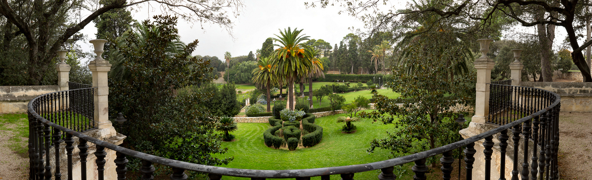
Sardinia's historic gardens, people and plants intertwined
A journey through scents and colours, art and history, to discover a landscape heritage consisting in seven historic gardens from the end of the 19th century, which combine architecture and botany. Stories of plants and people, of a passion for nature shared by remarkable characters who were apparently completely unrelated: the hero Garibaldi, the 'magnate' engineer Piercy, the 'enlightened' Marquis Aymerich. In 1866, the botanist Patrizio Gennari came up with the idea of having a collection of plants in the centre of Cagliari: that idea became the Botanical Garden, an expanse of five hectares with hundreds of specimens, including tropical plants and a section dedicated to plants from the Bible. Inside, we find an evocative archaeological area: four cisterns from the Roman era are incorporated into a Neoclassical project by the genius Gaetano Cima, who built a small temple to botanical science around them. Alongside the botanical garden is the Roman amphitheatre and the Orto dei Cappuccini.
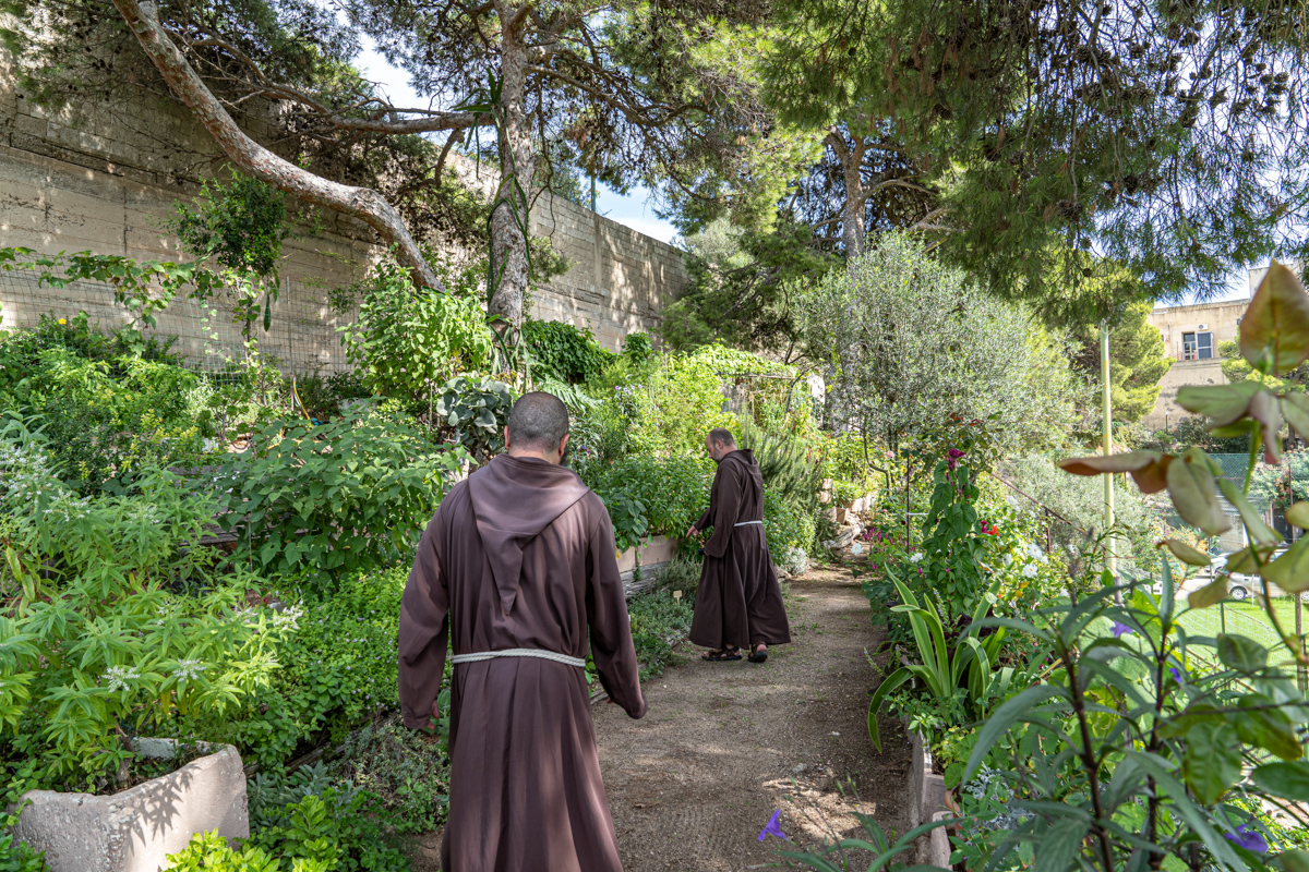
Franciscan places, interior well-being and a sense of community
Warm, familiar hospitality, simple yet precise rules, a slow pace that promotes reflection, moments of sharing and of learning, relaxing hours in an oasis of silence and peace. This is Franciscan hospitality, the “core” of an experience of physical and mental well-being and of cultural exchanges between travellers and those who host them; ideally, it brings together 14 Sardinian centres where followers of Saint Francis of Assisi have left traces that cannot be erased. In Gallura, since the early 13th century Franciscans have chosen the landscape of Luogosanto, where, perched among granitic rocks, is the Eremo di San Trano, today a popular pilgrimage site. In the town, the Franciscans built Nostra Signora di Luogosanto, a basilica with a Holy Door privilege, which is home to the queen of Gallura. Visit the sacristy to admire the diocesan museum, with holy items, statues and ex votos, including refined jewels. In their search for isolation, the friars climbed Mount Rasu: you can follow their steps and see the place where Giovanni Parenti, minister of the order after Francis, is likely buried. At Castelsardo, a hamlet perched over the sea, the friar minors of a convent have lived, over 500 years, in the church of Nostra Signora delle Grazie, home to lu Cristu Nieddu, a juniper crucifix that dates back to the 13th century and is blackened by time. At the Meilogu, in Mores, capuchin friars live in the convent of Sant’Antonio, the perfect place to try the Franciscan experience.
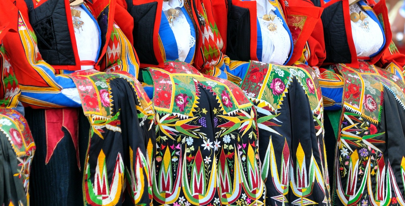
Patterns and textures of the soul
Original and imbued with meanings, the clothes and jewels are a fusion of signs left by the succession of different cultures in Sardinia: Nuragic, Phoenician, Greek, Byzantine and Spanish. Nothing was lost. Like the bright, coloured bonnets worn by the women of Desulo on festive days. They decorated them themselves, embroidering miniature details of the flamboyant Desulo dress: yellow, red and blue geometric designs alternated with embellishments based on the fantasy of skilled and sensitive artists. That of the women of Tempio Pausania was a different world, with their austere precious silk damask dress, which was completely black. They were admired for the elegant grace of their demeanour. On their heads, they wore a cascade of white lace, tied with filigree.