
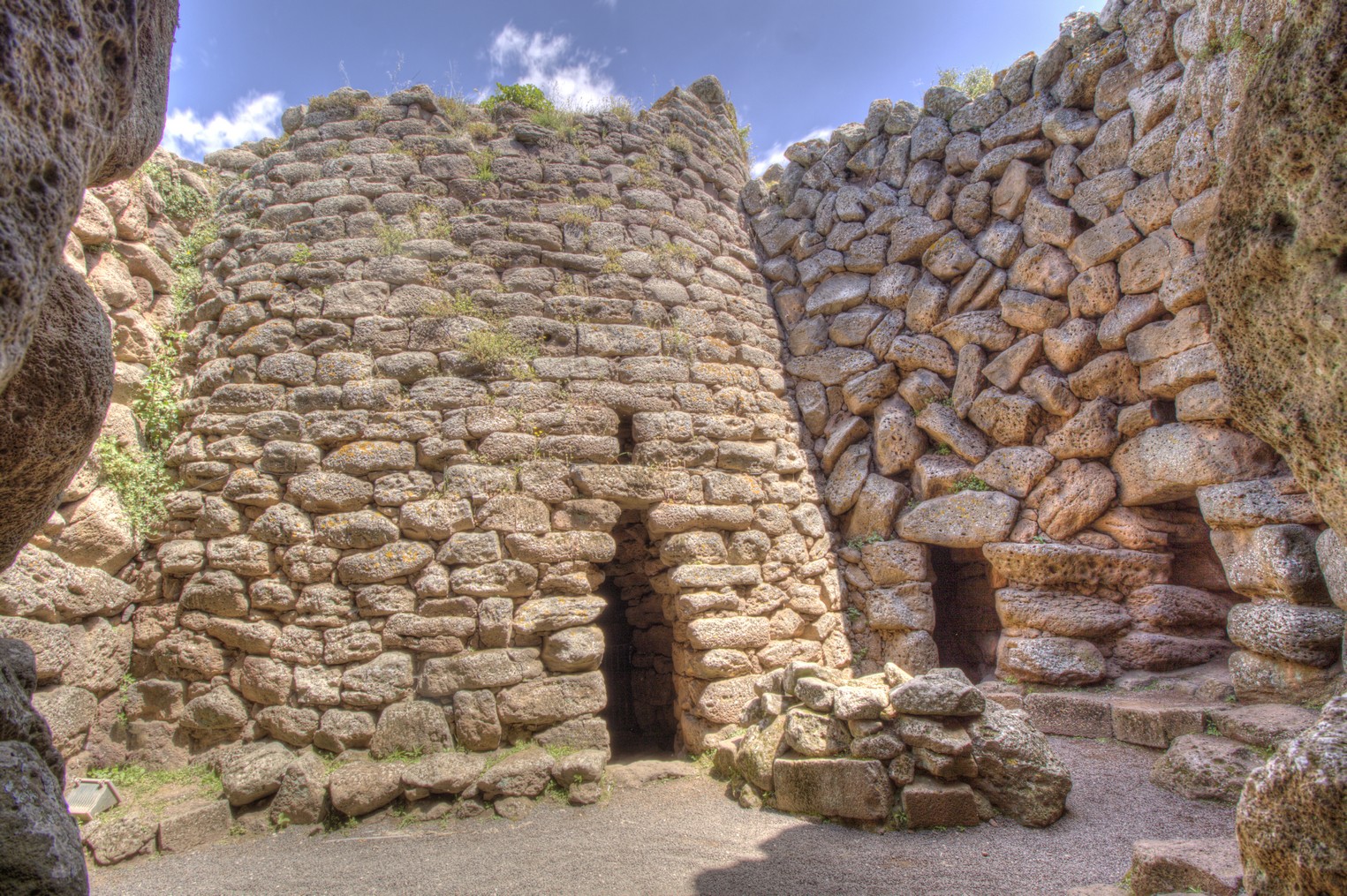
Nuraghe Arrubiu
The name of Red Giant is due to its grandiose size and the hints of red lichens that colour its basalt stone walls. The complex of Nuraghe Arrubiu, in the territory of Orroli, stretches for five thousand square metres and consists of a central tower (fortified tower) that is 15 metres high - originally it was double this height - surrounded by a formidable bastion formed by five towers, in turn surrounded by a defensive wall with seven towers joined by curtain walls. Inside it there are various courtyards. To the southeast there is another defence wall with five towers joined by masonry. There are a 21 towers in total. Within the fortified wall, of which the first of three floors is still remaining, by walking along a narrow passageway, you will reach the central room, that contains a fireplace and a ritual vase. The (false) tholos roof is still intact, as in some of the smaller towers.
In the courtyards, platforms, cisterns, fireplaces, niches, steps, entrances, corridors and covered rooms have been unearthed. All around there are numerous remains of huts. Along the eastern side there is a large, round one: it is the hut used for meetings, with a seat along the perimeter and a fireplace in the middle. The monument 'lived' between the 10th and 9th centuries BC, in alternating phases. After a collapse, it remained uninhabited until the 2nd century BC, when the Romans turned it into a wine-producing workshop: two tanks and tools for pressing the grapes bear witness to this. The date and importance of the site are confirmed by the artefacts: there is pottery imported from Peloponnesus which also confirms contact, which was not sporadic, with the Mycenaean civilization.
The archaeological area of Orroli is at the centre of the gentle hill of Pran' e muru, that watches over the territory along the Medio Flumendosa lake. The gorges, into which the river flowed, are now partly submerged by two artificial lakes. A territory deeply marked by the presence of man since prehistoric times, as is confirmed by the extraordinary concentration of vestiges from the past: from the Neolithic to the Bronze and Iron Ages to relics from the Roman Period and the Early Middle Ages. The Arrubiu was the stronghold, around which satellite nuraghi gravitated, which dominated strategic points and access roads. Near the complex, there is the Tomba dei Giganti della Spada. In the park of Su Motti, in a forest of downy oaks, there is a necropolis containing 15 Domus de Janas. In the village, there is the House of the Nuraghe Arrubiu, a museum created out of an ancient noble residence that includes twelve rooms in which the results of the excavations in 1981 are on show.

Solanas
About a kilometre of golden sand, between the promontory of Capo Boi, dominated by the Spanish tower of the same name, and a rocky peak covered in Mediterranean greenery. It is washed by a crystal clear, shimmering sea, reflecting shades of sky blue and emerald green. It is not a remote corner of paradise, but the beach of Solanas, a coastal district of the municipality of Sinnai. The village is a good 36 kilometres from the residential area and, in fact, it is an administrative area ‘overlooking’ the sea, in the eastern part of the Golfo degli Angeli. You can admire a large, spacious beach surrounded by captivating scenery, where the colours of the water and the vegetation covering the promontories on the edges of the beach stand out.
On the sandy stretch at the foot of Capo Boi, there is also a sand dune. The water is shallow by the shore and then quickly gets deeper and full of fish, which you can admire with a mask and snorkel. Thanks to the exposure to the wind, you can enjoy windsurfing and kitesurfing. You can also rent rubber dinghies and boats in order to observe the nearby stretches of coast, as well as exploring the depths, the little underwater caves and ravines, during exciting scuba diving: in fact, there is a scuba diving school in Solanas. Among the services available, there is a car park, refreshment areas and beach equipment rentals. In the village, you will find everything you need for a comfortable and relaxing holiday: accommodation facilities, supermarkets, chemist shops, bars and restaurants.
From the beach, you can get to the tower of Capo Boi via a trekking trail across the promontory, making your way through the Mediterranean scrub. From up there, at a height of 120 metres, you can enjoy a breathtaking view of the eastern part of the gulf. To your right, you can see the beach of Solanas all the way to its farthermost end and, on the left, on the opposite side of the promontory, the little coves of Pisanu and Sirena. Beyond, you will notice the western coast of Villasimius, Capo Carbonara and the island of Cavoli.
To the west of Solanas, there is another coastal enclave: that of Torre delle Stelle that, from an administrative point of view, belongs almost entirely to Maracalagonis. Here, you will find the beaches of Cann’e Sisa and Genn’e Mari, surrounded by greenery, with their white sand and a crystal clear sea. To the east, with the unusual ‘three-arched’ beach of Porto sa Ruxi, the spectacular coastline of Villasimius begins.
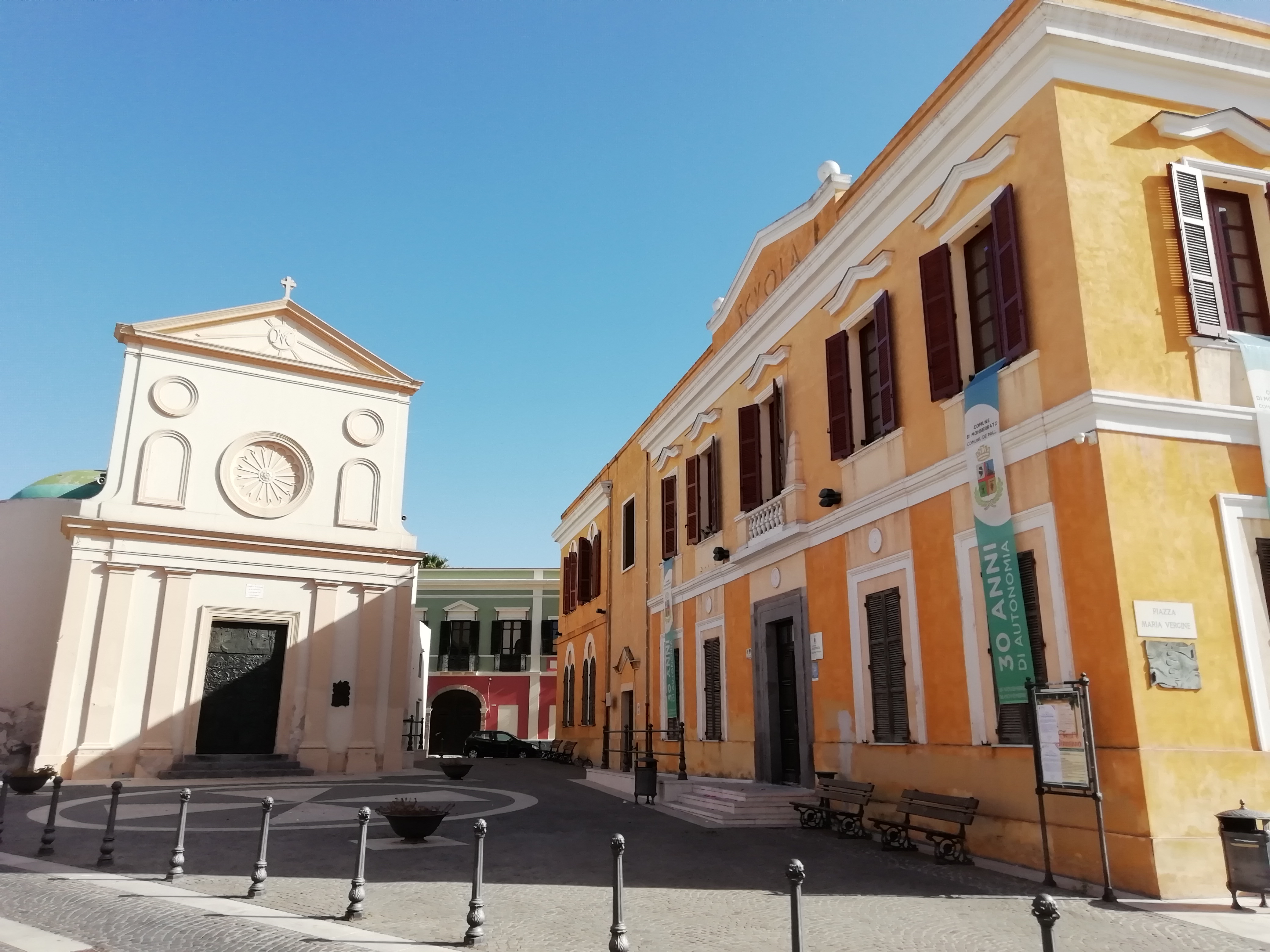
Sant'Ambrogio - Monserrato
Its origins can be found in two sources, one from 1654, in which construction had not yet begun, and the other from 1716, in which the building of two side walls was commissioned. It was in this period of time that the Church of Sant’Ambrogio was built in Pauli Pirri, a village that, in 1881, took on its current name of Monserrato. Today, its outline characterises the historic centre of the little town, on the outskirts of Cagliari, where Saint Ambrose is the patron saint, celebrated on 7 December. The architectural style is Gothic-Catalan, but when you observe the façade you will notice several unusual elements: an original double sloping roof and the battlements that decorate the lateral buttresses placed diagonally with respect to the main building. Above the portal, there is a pointed arch with an eyebrow element and an oculus, characteristic elements of Gothic architecture. The bell tower stands to the left of the entrance and was rebuilt in the late 19th century after the collapse of the original structure.
Inside, there is a single-nave layout with a barrel vault, onto which six side chapels open up through pointed arches, with dividing walls that were opened in recent times, creating the effect of side naves. In the chapel of the presbytery, you will see a star-shaped cross vault, with five distinctive hanging gems. On the sides of the triumphal arch, two niches contain the statues of Saint Ambrose and Saint Jospeh. Since the mid-19th century, the church hall has contained a marble pulpit and the high altar in multicoloured marble and gilded wood, sculpted in bas-relief style. You will notice another distinctive feature on the corbel to the right of the triumphal arch, where the symbol of the Sanjust family, who owned the fiefdom of Villa Pauli since 1426, is engraved.
500 metres from the church, you will find a small marble cross, placed on a column dating back to the Roman era. The monument, built in the 16th century and known as sa cruxi ‘e marmuri, bears an image of Christ. As well as marking the territorial limit of the Church’s jurisdiction, the point where the cross stands also indicates the place where executions took place. Then, a short distance from the parish church, walking through the narrow streets of the historic centre, you will see the imposing wooden portals of the Campidano houses, built in ladiri – bricks made of mud and straw – and tuff and characterised by the lollas, large loggias that surrounded the central courtyard.
Monserrato has a great wine-making tradition: its winemaking cooperative is the oldest in Sardinia and fine wines such as Nuragus, Monica, Moscato and Nasco are produced there. It is no coincidence that one of the most eagerly-awaited events is the grape harvest festival in September.
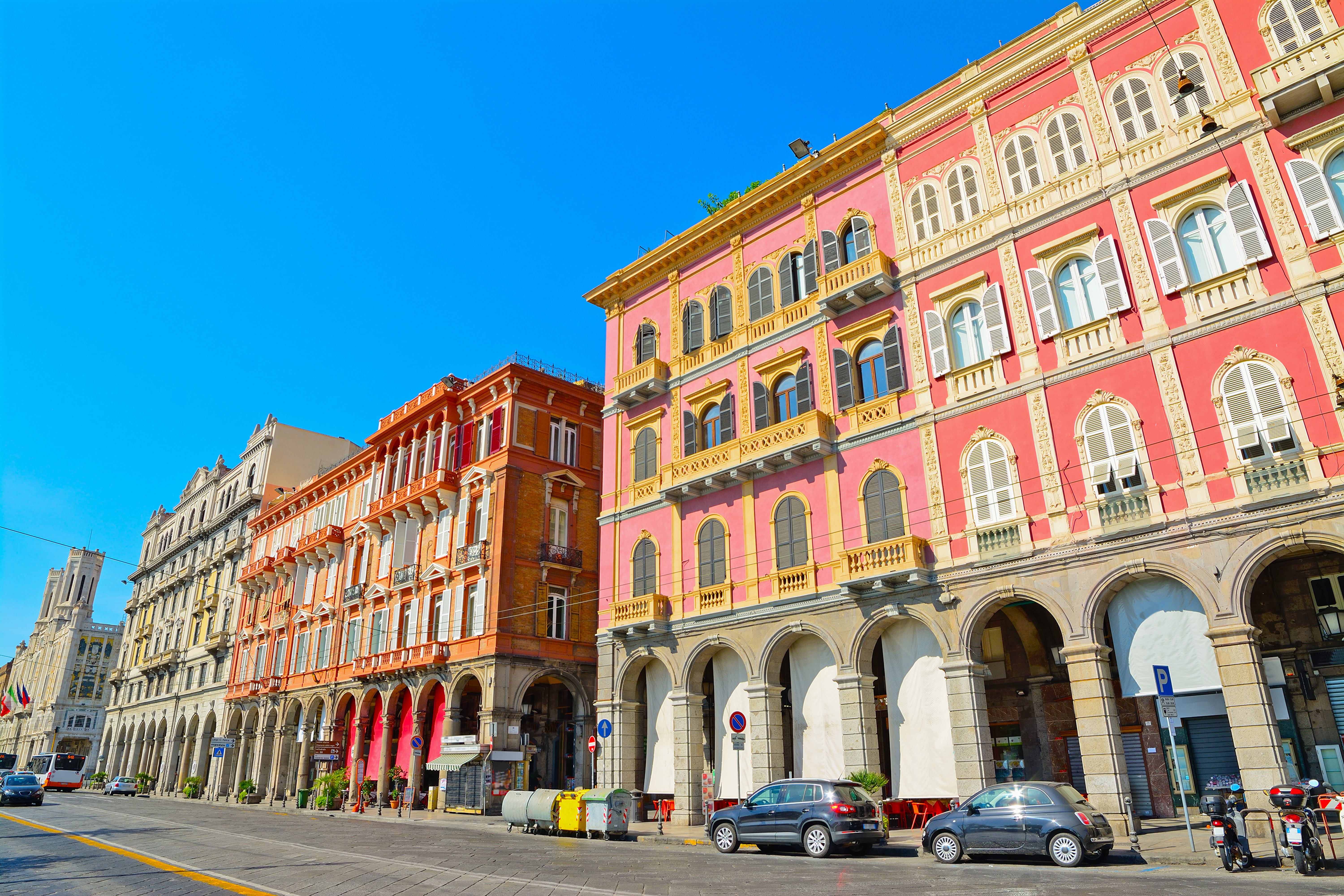
Palazzata in via Roma
For more than a century, it has been one of the symbols of ‘modern-day’ Cagliari, a varied and elegant mixture of colours and architectural styles overlooking the porticoes of Via Roma, which have become a destination for walks and shopping for tourists and residents, accompanied by the scent of the sea breeze. The seafront of the historic Marina district is characterised by a series of buildings constructed from the end of the 19th century, mainly in Art Nouveau style, with neo-Gothic and Renaissance additions. Before then, enclosed between the bastions of the church of Sant’Agostino, at the junction with the present-day Largo Carlo Felice, and the Dock, where the present-day Viale Regina Margherita starts, there were modest two-story homes, in which shops and trattorias were often opened on the ground floor. There were also facilities for leather tanning, while other huts, ‘specialised’ in the sale of fish, occupied the space adjacent to the pier. These were demolished for the construction of the port, starting in 1881, and a few years later a series of buildings started to appear, which you can admire today in all their splendour.
In reality, they were added to the pre-existing Palazzo Devoto, built in 1870 and next to the late seventeenth-century church of San Francesco da Paola. The first were the Magnini Palaces, on the two corners between Via Roma and Via Baylle. Later, Palazzo Vivanet was built and was the first example of neo-Gothic architecture in the city, with a series of porticoes with pointed arcades; Palazzo Garzia, between Via Napoli and Via Barcellona, and Palazzo Leone-Manca, which contained the Olympia Cinema until recently. Beyond the church, Palazzo Vascellari-Beretta and Palazzo Ravenna were built, between which there is the modern building in which the Regional Council of Sardinia is located. The stretch facing Piazza Matteotti is dominated by the Palazzo Civico (Town Hall). It was inaugurated in 1907 and represents the choice, with a strong ideological nature, of the municipal administration in office at the time, led by Ottone Bacaredda, to move the centre of the city’s power from the ‘aristocratic’ Castello district to the Marina district. The building is made of white limestone, with Art Nouveau decorations and references to Gothic-Catalan models: you will particularly be drawn to the two octagonal turrets and the four obelisks in the corners.
Marina is a district to explore, losing yourself along its narrow little streets, looking around the shops and tasting the town’s traditional dishes at the numerous restaurants and taverns. In the ‘heart’ of the district, stands the Parish Church of Sant’Eulalia. In its basement, you can visit the archaeological area and the monumental crypt. Next to the church, you’ll find the Treasure Museum, containing a vast artistic heritage from the adjacent sanctuary and the churches of Santa Lucia and the Holy Sepulchre, as well as the documents from the parish archive and the archconfraternities of the Crucifix and the Holy Trinity.
Casa Steri - Museum of Sardinian Farming and Food Culture
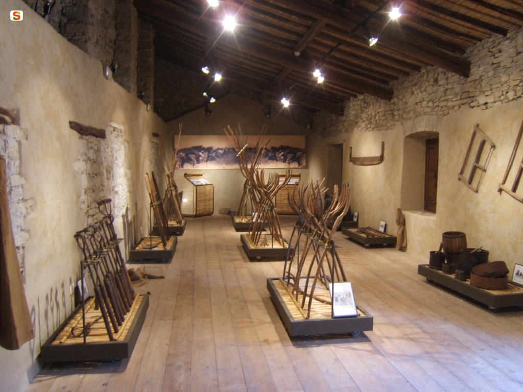
One of the most distinctive aspects of Sardinian cultural traditions is food, narrated in its evolution over thousands of years: not only foods, but also the cultivation, preservation, transformation and production techniques. All this inside a seventeenth-century Campidano manor house ‘with a courtyard’: it is Casa Steri, in the historic centre of Siddi, a rural village ‘lying’ at the foot of the giara of the same name. The theme of the museum exhibition is the history of the Island’s food since the Nuragic age and it is divided into various spaces, residential and productive. You will visit rooms dedicated to the production cycle of milk and oil. It is no coincidence that Siddi is part of the Italian ‘Città dell’Olio’ (Cities of Oil) circuit. You can also admire a grain mill with a rare eighteenth-century millstone powered by horses. In the kitchen, you will see traditional objects such as sieves, baskets and clay scivedde (containers).
You can also visit rooms used as shelters for work and farmyard animals, among which stables, where tools for branding livestock and wine-making equipment are on display. There is also a granary, with various tools needed for working in the fields: ploughs, hoes, sickles and seeders. In the various rooms, there are panels with texts describing traditional farming activities, which the inhabitants of the village helped write, as a ‘historical memory’ and source of knowledge handed down by the community. Events and temporary exhibitions are often held in the ‘reception room’ of the house, in which the walls are painted with Art Nouveau motifs. Workshops are also periodically organised in the museum, during which you can learn techniques for making products like pasta, bread and desserts and learn about the characteristics and curiosities of the products of Sardinian cuisine.
The Siddi territory combines captivating natural environments with an important archaeological patrimony: the two aspects coexist in the park of sa Fogaia, a kilometre and a half from the town. In a forest of holm oaks and Mediterranean scrub there are numerous plant species, aromatic plants and flowers, together with about 60 bird species – which you can learn more about at the Ornithological Museum of Sardinia, the only one of its kind on the Island –, without forgetting reptiles, hares and foxes. In the upper part of the park, you’ll find the nuraghe sa Fogaia, with a more ancient core and buildings added later on. A few kilometres further north, on the Giara di Siddi, one of the most famous and best-preserved Giants’ Tombs awaits you: sa Dom’e s’Orku. It is a megalithic tomb dating back to the Bronze Age and was made with large blocks of basalt from the same giara, set in a splendid landscape.
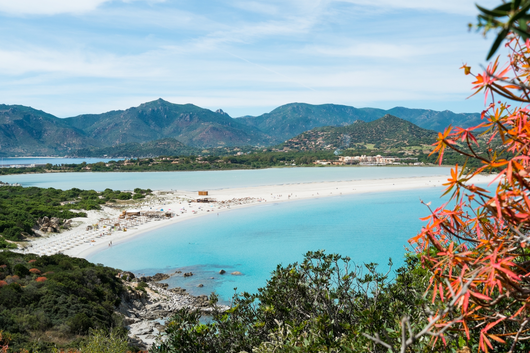
Notteri - Timi ama
The Notteri beach is a carpet of sugar-fine white sand, lapped by a crystal-clear sea. That is why it is often picked as a set for films and TV commercials. Its pristine natural environment is enhanced by the nearby Notteri marsh, home to the stately pink flamingos.
The beach is easily reached following the road signs to Villasimius, along Provincial Road SP 17. Once in town, drive along the main road heading south, and follow the signs to Notteri.
In addition to its natural attractions, the beach has a number of services: it has a spacious parking area also suitable for campervans, a hotel, bars, a restaurant and night clubs. It is also accessible by persons with reduced mobility. Its gently sloping seabed makes it safe for children. Rental of sun umbrellas, beach loungers and pedalos. Its good exposure to the wind makes it much loved by windsurfers. It is also a favourite destination for breath-hold spear fishermen and scuba divers.
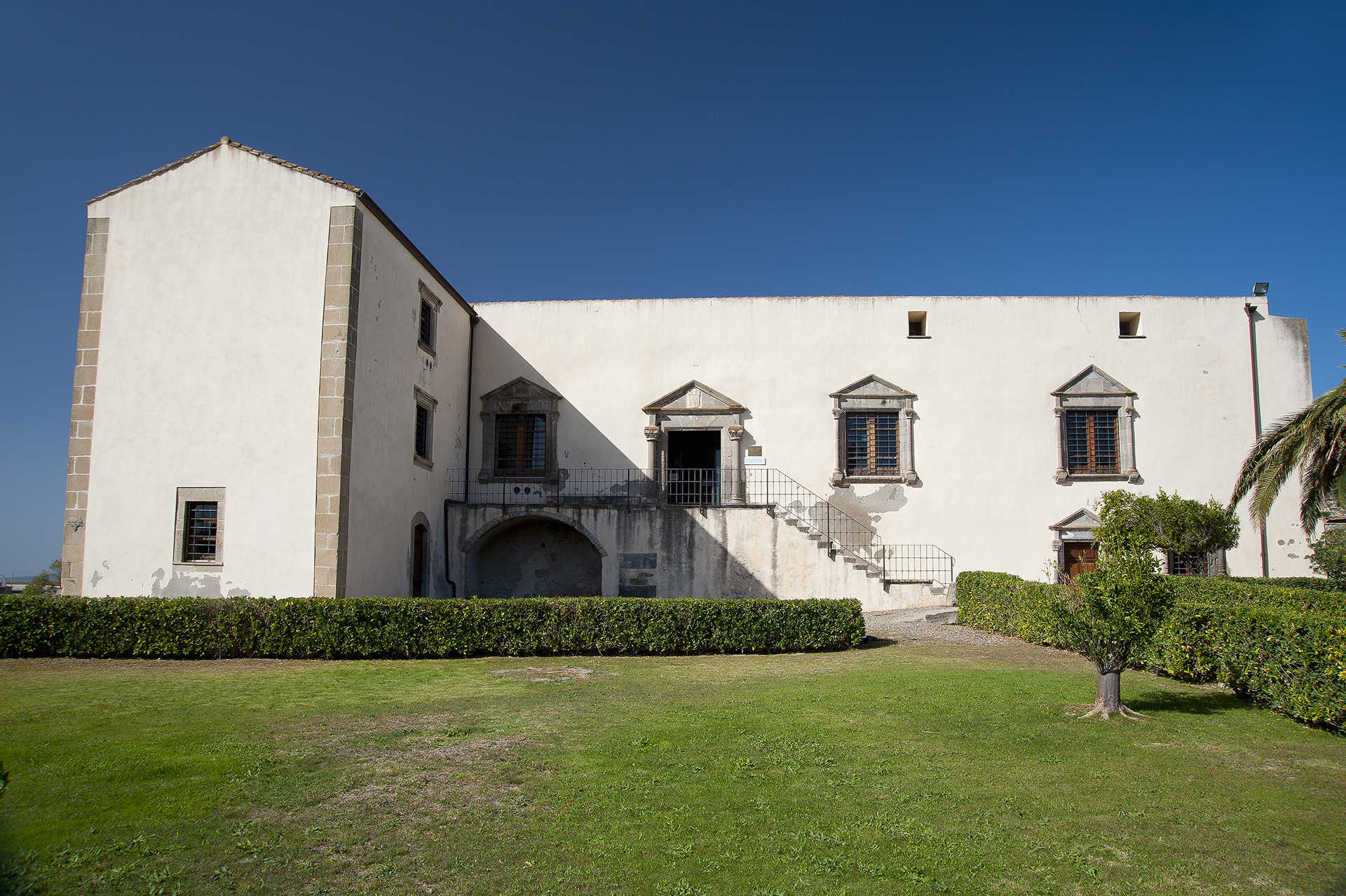
Casa Zapata
Noble power, good taste and a display of luxury combined with a priceless cultural patrimony. In Barumini the beautiful dwelling of the Zapata family, the building of which was ordered by Don Azor, alcalde of Cagliari, at the end of the 16th century, over the ruins of a nuraghe. Since 2006, the Spanish residence has been a museum centre. The building is a rare example of Hispanic civil architecture in Sardinia, built based on classical-style models. You will see this clearly in the features of the residence, divided into two floors, and in the architectural decoration.
The façade has a portal and windows with tympana resting on smooth columns with a double torus base, grooved door-jamb and coffered capitals. The family crest is carved into the central tympanum: a vermilion shield with three gold-checked shoes. The same elegance can also be seen in the staircase. You will recognize the buyers’ classical taste in the Zapata family palace in the Castello district of Cagliari.
In 1990, the 'musealization' of the house began, in order to enhance the value of the findings from the nearby Nuraxi, the greatest piece of evidence that we have inherited from the Nuragic civilization. It was found that it had been built over another complex nuraghe, renamed Nuraxi e' Cresia because of its proximity to the parish church, frequented between the 14th and 10th century BC. The excavations safeguarded the structure of the house and, at the same time, made the view of the complex visible from above, with suspended walkways and transparent floors: you will enter a noble palace and suddenly find yourself above a nuraghe. Inside Casa Zapata two towers are visible (central and eastern), while the other two, the double defence wall and the village are outside the palace.
The nuraghe is part of the archaeological section of the museum, along with a collection of over 180 artefacts found at Su Nuraxi, among which a famous model of a nuraghe made of limestone. Another two sections are set up in the ancient rustic courtyard adjoining the palace. In the historical-archival showcases, you will see thousands of documents - original papers and digitized documents - that tell the story of the Zapata family from 1541, when Azor acquired the fief of Barumini, Las Plassas and Villanovaforru. The ethnographical section hosts tools for daily and agricultural activities dating back to the early 20th century. Here, the regional museum of the Launeddas is located. These are ancient, traditional Sardinian musical instruments with three pipes.
Porto Botte
The beach of Porto Botte has coarse sand mixed with pieces of seashell. There is the added bonus of a pool nearby where it is possible to admire flamingos and other migratory aquatic birds.
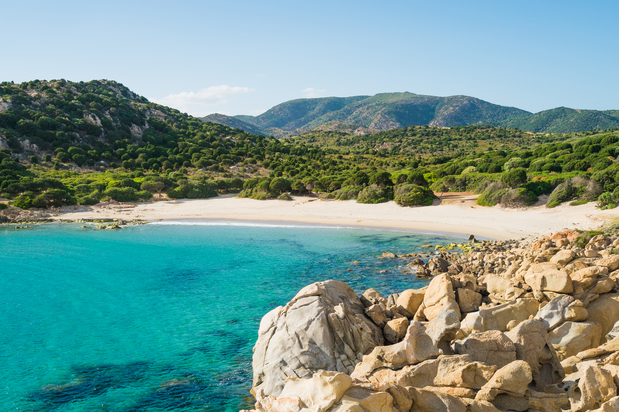
Cala Cipolla
A charming stretch of fine, golden sand, enclosed between two pink granite promontories that stretch towards the sea, forming a natural pool. Behind it, there are sand dunes with Mediterranean vegetation and a pine and juniper forest. Cala Cipolla has a distinctive appearance with solitary, wild nature: it is one of the most captivating beaches of the Chia area, in the territory of Domus de Maria, three quarters of an hour from Cagliari. It is a little to the east of the promontory of Capo Spartivento, over which a lighthouse stands, accessible via a path, from which you can enjoy a view of the entire southwestern coast.
The splendid little cove is hidden between the hills and is characterized by a transparent sea, with iridescent colours that range from deep blue to green. The sandy seabed has shallow waters for several tens of metres from the shore, making it perfect for children. Every now and then, small rocks interrupt the uniformity of the waters. All around, the Mediterranean scrub frames the little cove. It is an ideal destination for surfers and it is popular with those who like underwater fishing and scuba diving. The car park is four hundred metres from the beach, where there is also a kiosk-bar.
The fine, golden sand is typical of the entire Chia coast, which is one of the most popular tourist locations in Sardinia: over six kilometres of dreamy coves and beaches that you can admire from the 17th-century Aragonese tower. A promontory separates Cala Cipolla from Su Giudeu, a beach used in films and advertisements. Further to the east, there is Sa Colonia, a kilometre of sand between two promontories, Cala del Morto, a small, sheltered beach with shallow waters, and Cala della Muscia, which can only be reached via the sea. Not to be missed is Su Cardolinu (meaning mushroom), a little island joined to the mainland by an isthmus of sand, where the tophet of the Phoenician city of Bithia (8th century BC) was unearthed, and can be visited on foot from the beach of Porticciolo. Close to it, there are two ponds: you will notice and take close-up photographs of the great flamingos, in the company of herons, coots and Great Cormorants.

San Francesco - Iglesias
There is no certainty about when the Franciscans arrived in Iglesias: according to one theory they were already present at the time of the Pisan domination, while others think that they arrived after the power was seized by the Aragonese Crown (1324), which imposed the religious order it preferred on the city. In both theories, the first building of the Church of San Francesco, one of the main examples of Gothic-Catalan architecture in Sardinia, must have emerged later. It is not even clear whether or not it was constructed on pre-existing Benedictine structures. In any case, the present-day building is a 16th-century renovation, with subsequent interventions that did not change its general appearance. A few engravings of decorative elements are helpful in confirming its origin: a capital and a holy water font show the date 1558, while the year 1584 appears in the chapels on the sides of the presbytery.
On the gabled façade, made of red trachyte ashlars, you will notice two oculi and a rose window, in line with the entrance portal, decorated with jambs in bundles and monolithic architraves with a pointed relieving arch. The interior has a single nave, divided into seven bays, with a wooden roof. Various capitals bear coats of arms and inscriptions: in addition to the year of installation (or completion of the works), you will notice the coat of arms of the Franciscan order (two crossed arms) and of the Iglesiente municipality in the Spanish period. The apse is narrower and lower than the nave, closed by an ‘umbrella-shaped’ vault. On the sides of the nave, seven chapels open up per side and it has been suggested that the third on the left dates back to the original fourteenth-century church building, because it is very different from the others: the entrance arch is smaller and the roof, with a cross vault, is plastered. On the back wall of a room added to the first chapel on the left, you can admire the Retable of San Francesco, a work attributed to Antioco Mainas, a painter from Cagliari of the Stampace school. The altarpiece was painted in tempera and oil around 1560 and has the double triptych pattern, with a five-compartment predella. Among the scenes painted in the compartments, there is the Crucifixion, a Madonna and the Stoning of Saint Stephen.
Iglesias already has Catalan-Aragonese traits in its name, which continue to appear in the city’s traditions, such as the Easter Holy Week rituals, particularly during the processions of the Mysteries. Another event not to be missed, in mid-August, is the medieval historical parade. Among the monuments, the Castle of Salvaterra, built by the Pisans, and the Cathedral of Santa Chiara, dating back to the Middle Ages, stand out. For over a century, the Iglesiente area was the centre of the historical mining period, while today it is part of the Geo-mining Park of Sardinia. In addition to the city museums, you can visit the mine of Monteponi and the mining sites along the coast of Nebida and Masua, among which the spectacular tunnel of Porto Flavia.