
Sa Fogaia park
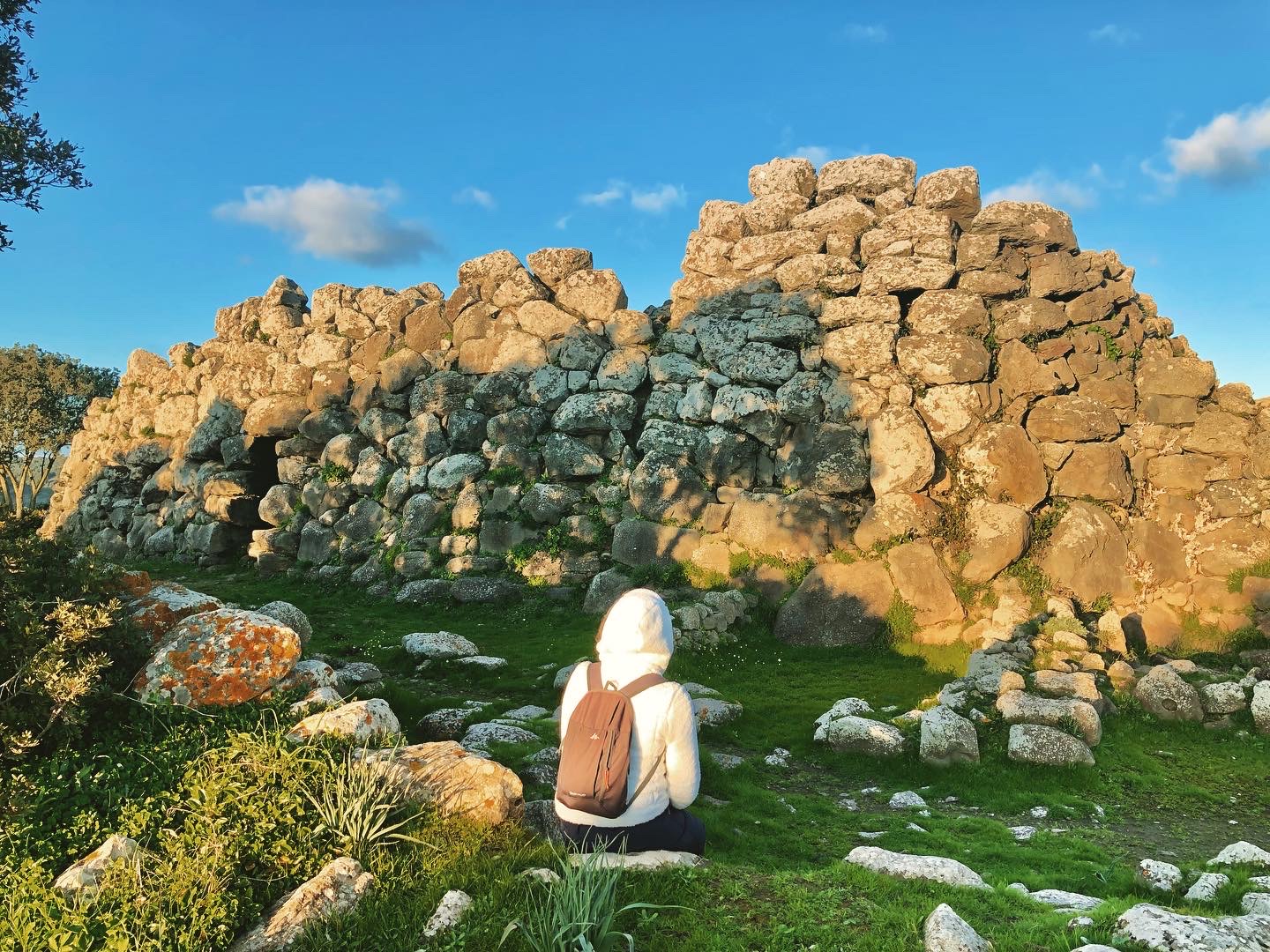
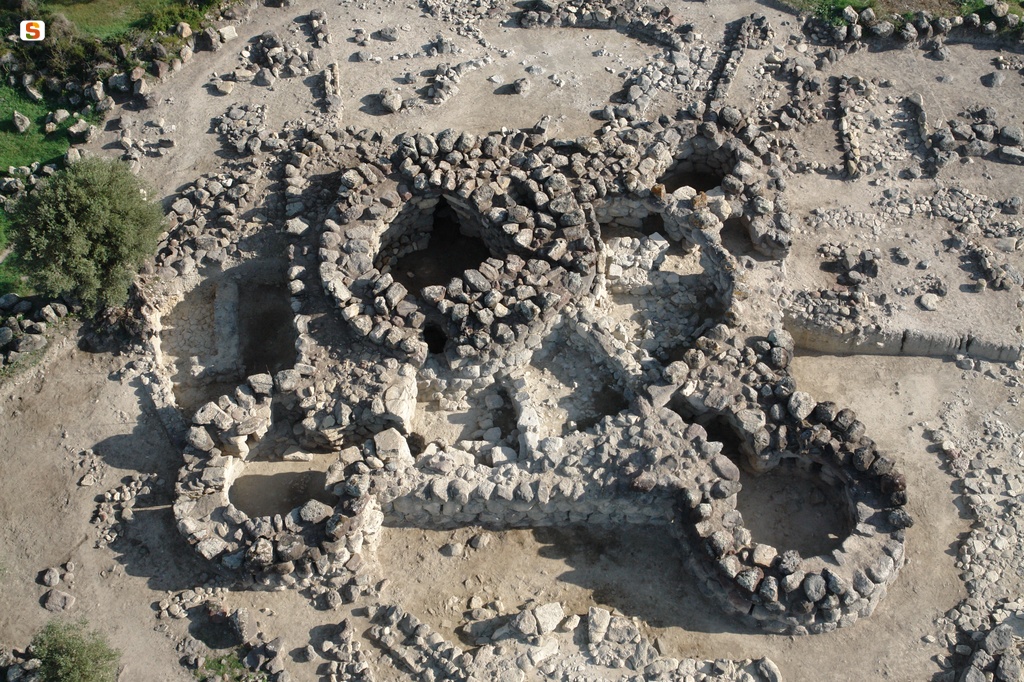
A very ancient nuraghe, ‘from the very beginning’, with unique shapes, and a prehistoric village with a station where obsidian was processed along with a ‘garden’ of great environmental value around it. These are the elements that characterise the park of sa Fogaia, inviting you to visit it. It is a green oasis that covers the eastern slope of the Giara di Siddi, just over a kilometre away from the beautiful village of Marmilla. The ‘upper’part of the park is the scenic area, where you will have a view of the Marmilla hills and the Giare of Gesturi and Serri, as far as the view of the Gennargentu massif. In a strategic position, on the edge of a precipice, you will find the corridor-type nuraghe of sa Fogaia. It was built over 300 metres above sea level on the rocky outcrop, using dry and overlapping interlocking blocks of basalt.
The building shows traces of various construction phases: the nucleus is represented by the ‘protonuraghe’, i.e. the archaic version of the famous construction, with an unusual ‘Y-shape’ layout. It is thought that its origin dates back to the beginning of the Middle Bronze Age and, later on, two other megalithic bodies were added alongside it, as well and a series of secondary spaces. To enter, you can go up a stepped ramp carved into the thickness of the wall: the entrance is in fact raised five metres above the walking surface. In the inner corridor, you will notice more steps, which once led to a terrace that is no longer there. Parts of the roof of the two adjoining buildings have survived and were made in different styles: jack arch, tholos (false dome) and ogival. In several rectangular rooms in the internal courtyard, there have been finds dating back to the Late Punic and Roman periods. Around the nuraghe, you will notice traces of a village where obsidian was found, proof that there was a stone workshop in sa Fogaia dedicated to working on the ‘black gold’ from Monte Arci.
The archaeological theme is not the park’s only element of charm: living in the holm oak woods and Mediterranean scrub, there are more than 150 different plant species as well as a wealth of wildlife. You can stroll surrounded by the colours and scents of wild orchids and numerous aromatic and medicinal plants. One path in particular, known as su mori ‘e is erbas (the path of herbs), which was once an old mule track used over the centuries by the community of Siddi, will accompany you as you observe the most typical floral species of Marmilla, described on special wooden signposts. Among the park’s ‘residents’, there are about 60 types of bird, such as the barn owl, the owl, the raven, the kestrel and the lapwing; you might also spot weasels, hares, foxes and various species of reptile.
Continuing in the northwesterly direction, you can enter the Giara di Siddi, in which there is one of the largest and best-preserved Tombs of Giants in Sardinia: sa Dom’e s’Orku that, just like the nuraghe Sa Fogaia, was built using large blocks of basalt between the Early and Middle Bronze Ages.
Monte Urpinu
One of the oldest and largest green lungs of Cagliari is home to a variety of picturesque local characters and historically significant buildings. Mount Urpinu park spreads out over 22 hectares on its eponymous hill between the Molentargius-Saline natural park and the Bonaria hills. It owes its name to a now-extinct colony of foxes that populated it until a few centuries ago, when it was still covered in wild vegetation. In fact, Urpinu means “little fox” in Campidanese. Monte Urpinu was also the site of some small military forts until it was bought by the aristocratic Sanjust family. The new owners first had it reforested, planting numerous Aleppo pines, and then restored a small church, now known as the Aragonese Church, originally built between the 17th and 18th centuries over the remains of a small Byzantine sanctuary.
In 1939, Monte Urpinu became the permanent property of the City of Cagliari. It was soon turned into an urban park, although the side that looks out over the Molentargius swamp remained at the disposal of the Italian air force, who constructed a base and some underground fuel storage tanks there. Another area of the hill was used as a limestone quarry. In 2007, the military abandoned its base, and several decades before that the park underwent a further reforestation project.
It is now one of the favourite outdoor leisure spots of local residents. Here you can walk along a series of paths or go for a good run. There is also exercise machinery and a popular tennis club. Families take their children to the park to enjoy the spacious equipped playground. Picnics can be organised in the shade of trees and next to some artificial lakes. There are even two hectares dedicated entirely to dogs. And speaking of animals, the local fauna is also one of the park’s attractions. There are swans, moorhens, mallards, geese, tree frogs, turtles and colourful peacocks. The park is also home to a colony of cats. Equally interesting is the flora: in addition to the pines, you will spot willow trees, oleanders, junipers, and holm oak, mastic and olive trees.
The eastern flank of the hill has a panoramic road from which you can enjoy gorgeous views on both sides: from the Belvedere you’ll see the spectacular Golfo degli Angeli (Gulf of Angels), spot the Sella del Diavolo (Devil’s Saddle), Molentargius and its salt flats, and the Poetto beach. On the other side, looking west, you’ll see San Michele hill, crowned with its medieval castle, the historical districts of Villanova, Castello and Marina, the harbour and the Stagno di Cagliari (Cagliari Pond).
Monte Claro
The walls embrace a large garden where nature, history, culture and wellness reign. Monte Claro park sits on the summit of the eponymous hill, in the centre of Cagliari, a short distance from another of the seven hills on which the capital was built, San Michele hill. This park spreads out over 25 hectares delineated by walls that once encircled an old psychiatric hospital. In the late 19th century, the Province of Cagliari rented the area to house the unwell, and over time it became the pavilions of the hospital. All around were orchards, vineyards and crop fields where sometimes even the patients worked. The hospital was shut down in 1998 and the entire area was repurposed as a city park, opening in 2001. The main building, Villa Clara, where the hospital’s director once lived, is now the metropolitan library.
When you enter from the main gate, you’ll walk over a road lined by oak trees, alongside which are some of the stone “sound” sculptures done by the artist Pinuccio Sciola. If you rub one with your hand or a small stone, it makes pleasant sounds. The road winds past a picturesque pond home to water turtles, swans, geese and ducks. As you continue, you’ll come across the ‘fontana logo’, a pond equipped with technology that stages a fantastic series of jets of water. The symbol of the park is next to it: a stylised twig. The logo echoes a decoration from a bowl found in a tomb discovered in 1905. Monte Claro is, in fact, an archaeologically important area: the culture of Monte Claro gets its name from the traces of a pre-Nuragic settlement discovered here. The park is also home to the remains of a building that may have been used as a sacred well and, not far away, a mysterious 4th century BCE tomb where various amphora and the bones of a couple, buried in an embrace, were found. The mystery thickens, as this was the only Punic Age tomb discovered on the hill from an era when the vast, nearby necropolis of Tuvixeddu was still in use.
Aside from the historical and archaeological aspects, Monte Claro will surprise you for the richness of the vegetation that thrives here: carob, mastic, oleander, olive, pine, oak and willow trees, as well as mulberries, roses and hibiscus bushes. The tropical garden is home to such aromatic plants as laurel, myrtle and rosemary. The park is an ideal place for a nice jog or walk. Sports fields have also been laid out here, especially for soccer and five-a-side football, and there is a skating rink. There are even two areas set aside especially for dogs. Monte Claro is also a venue, especially in summer, for shows, concerts and a variety of cultural events.

Murals, open-air art galleries
It was a group of great artists, in a historical moment marked by social and cultural ferment, that triggered the creative ‘spark’. The story of the murals in Sardinia originates in a lively little village in the Campidano countryside and then others gradually joined in, from Barbagia to Planargia and beyond, towards the north. In short, the Island became the capital of mural painting. This was partly to bring new life to decaying picturesque views, to walls in ladiri and semi-abandoned alleys, but it was above all to give impetus to the desire to make the cry of protest and suffering that involved entire communities heard. Years later, there is a new ‘flame’, a free and spontaneous one. This time, the artists transforming and reviving the urban fabric, some local and others not, are young but already internationally famous. From murals to street art, from protest to experimenting, Sardinia is always the protagonist, like an immense palette to fill with colour.
Nuraghe San Pietro - Ussaramanna
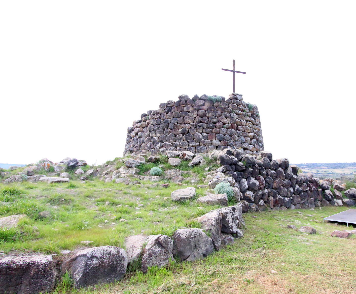
An impressive iron cross stands out on the top of it and is not the only link that this fortress has with Christianity: in fact, its name evokes the memory of a medieval church that has now disappeared. The nuraghe San Pietro stands on the edge of the town of Ussaramanna, on the top of a hill surrounded by the rolling landscape between sa Jara Manna (the Giara di Gesturi) and the Giara di Siddi. It is a complex building, constructed with large sandstone blocks, in which there is a keep, standing ten metres high and with a diameter of 13 metres, surrounded by a bastion with four towers connected by a curtain wall. Three of the four lateral towers have diameters of around nine metres, while the one in the north-eastern corner is larger: its diameter is the same as that of the keep. This distinctive feature has been explained by the theory that this may originally have been a trefoil nuraghe and was subsequently modified by inserting the fourth tower.
From the entrance, located on the south-east side, a corridor opens up and has an ogival roof, which has partially collapsed. Before entering the main chamber of the keep, on the left you will notice the remains of the flight of steps that provided access to the upper level. In the internal space, which has a circular layout and is now without a roof, you can see two opposing niches, also with an ogival ceiling. Another room appears in front of the stairwell and is difficult to interpret: judging from its position and shape, it appears to be a sentry box. Around the building, you can also see traces of rooms with a quadrangular layout: it is thought that they date back to Roman times, providing evidence of a thousand years of continuity of use of the site. The possibility that the nuraghe also had funerary functions until the Byzantine era cannot be excluded.
In the territory of Ussaramanna, known for the very high quality of its of olive oil and Malvasia and Nuragus wine production, there are traces of evidence of it being frequented since prehistoric times. The legacies dating back to the Bronze Age are not limited to San Pietro: in the village’s surroundings, you can also see the nuraghi Santa Barbara, Cabonu, Molas and su Sensu. Then, in the Bingias Beccias area, a necropolis dating back to the Imperial age has been discovered. You can continue your archaeological tour in the heart of Marmilla by moving a few kilometres east: in the territory of Siddi, you will find the majestic and well-preserved Giants’ Tomb of sa Dom’e s’Orku, made up of rows of large basalt blocks, as well as the park of sa Fogaia, with a nuraghe in a scenic position and a ‘garden’ of great natural value at its feet.
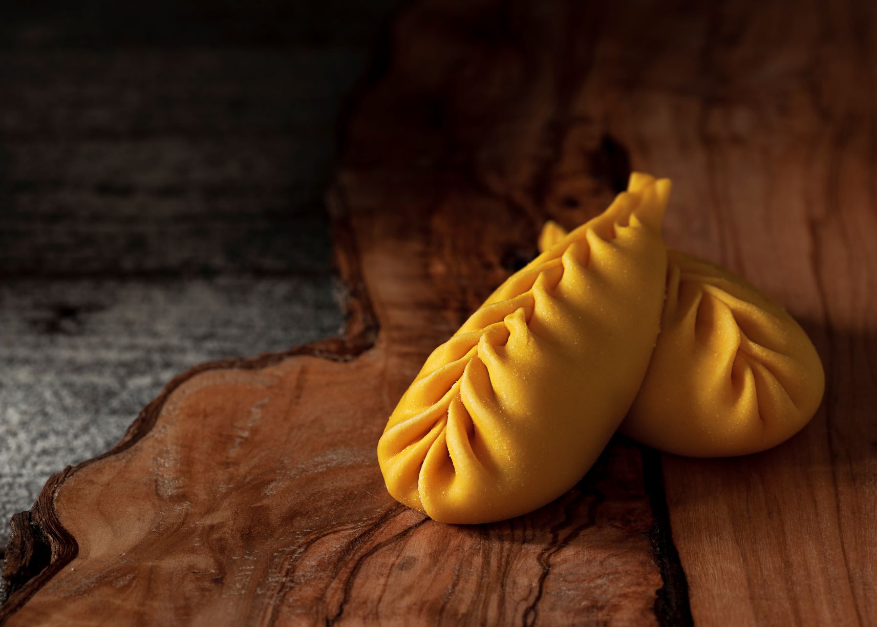
Homemade, like in the past
Each has its own preparation ritual, with meticulous and codified gestures, always the same, handed down from mother to daughter. The traditional pastas, both dry and fresh, are a bond between everyday life and celebrations. They are ever-present in moments to be remembered and are daily protagonists at the table, at home, in restaurants and in holiday farms. Their origin has been lost over time: wheat seeds have even been found even in the nuraghi, so it is no coincidence that Sardinia became the ‘granary of Rome’. The tradition has been cultivated (literally) up until the present day, generating a unique and solemn mixture of art, conviviality and taste.
Pantaleo
More than a forest, it is a true natural treasure: a third of its surface is a wildlife protection oasis, containing the most extensive holm oak forest in the world and the largest eucalyptus tree in Sardinia, and it is also home to an unusual ‘hybrid’ plant species. The state-owned forest of Pantaleo stretches for approximately 4200 hectares in the territories of Santadi and Nuxis and is part of the Regional Nature Park of Gutturu Mannu. Among the tree varieties, the holm oak is dominant, but you can also admire cork oaks, yews, hollies, Mount Etna brooms and examples of elder and Montpellier maple trees. Curious holm oak-cork oak hybrid trees have also developed and can be seen along the paths marked out for excursions. In spring, you can also admire colourful peonies.
The forest ‘rests’ on rocks that have various origins from all eras, starting from the Palaeozoic period. Much of it extends between granite formations, which you can see in pinkish coloured spikes, while there is limestone in the western part. The wildlife is equally interesting: Pantaleo is one of the habitats of the Sardinian deer and it also hosts colonies of fallow deer and weasels, while wild cats, martens and foxes find refuge there. Sardinian hares - at risk of extinction until a few decades ago - are bred in a wildlife centre, with around 200 specimens, and the centre can also be visited via an educational path. The birds of the forest are mainly migratory and various birds of prey, including the golden eagle, goshawk, peregrine falcon and sparrowhawk, nest here.
In the locality of is Figueras a resting place awaits you, equipped with tables, with streams flowing around it and hiking paths branching off. Walking along them, you will be able to see the tallest eucalyptus tree on the Island, which is 27 metres high and has a diameter of more than five metres, as well as traces of the activities of charcoal production and distillation of wood, which started at the beginning of the 20th century and continued until 1981. The charcoal produced in the forest was transported via railway, the route of which can still be seen, loaded on ships at Porto Botte heading to the French ports.
Pantaleo is nestled in a natural area of inestimable value, as it is adjacent to the state-owned forests of Pixinamanna, is Cannoneris, Monti Nieddu, Gutturu Mannu and Tamara Piriccu. In all, the complex stretches over 22 thousand hectares of greenery. In these oases, you can admire a huge patrimony of plant life and wildlife, as well as archaeological sites and traces of mining activity. If you then want to learn more about some species, you can move further north to the Oasis of Monte Arcosu, the largest WWF reserve in Italy: it is ‘inhabited’ by about a thousand Sardinian deer.

Nivola & Sciola, sculptors of Mother Earth
The silent poetry of Sardinian stones speaks in their works, from the prehistoric stones the nuraghi, the domus de Janas, the Tombs of Giants and the holy springs to those of the ancient rocks, witnesses of timeless geological eras and powerful cataclysms. It didn’t take much for Costantino Nivola and Pinuccio Sciola to capture the soul of their Land and the cosmic and material energy imprisoned within it. They have revealed all this in their sculptural works, with extraordinary sensitivity and an ability to summarise cubist, surrealist and primitive artistic tendencies.

Anchored in the seas of Sardinia
You can reach the most secret and isolated stretches of coast on a sailing boat, as well as hidden coves to be discovered amid the fjords, enchanting reefs and cliffs, to admire while zigzagging coast to coast, not to mention little archipelago groups surrounded by underwater life to explore by snorkelling, sand dunes and Caribbean beaches that can be reached by swimming or by canoe. Days on a sailing boat are spent between strips of Eden, memorable settings for unforgettable sunsets. It is a green, sensory, exciting and fantastic way to experience the Sardinian sea, chosen by boaters as a paradise of beauty, where boredom is banned.
Nuraghe San Marco
It is one of the most interesting examples of a Nuragic fortress ‘repeatedly lived in’ by the civilisations that followed one another over thousands of years. The nuraghe San Marco stands on the eastern outskirts of Genuri, on the slopes of the southwestern side of the Jara Manna, the largest and most famous giara. The basalt used for the construction of the monument comes from the plateau, which was also a ‘source’ of sustenance and resources for the peoples who inhabited the Marmilla region, while marl was used for the restoration work that took place in later phases. The building has a complex structure, consisting of a keep and three towers, and it is surrounded by a rampart with another five towers, except on the north side, perhaps because the builders considered the natural ‘protection’ of the Giara plateau sufficient.
Curiously, the south-east tower has a smaller diameter than the other two, while the wall to the north-east, which follows the profile of the central tower, has sometimes been interpreted as the wall of a fourth corner tower. In the space between the keep and the connecting curtain walls between the towers there is a sickle-shaped courtyard, which you can access through the entrance to the structure on the southern side. From the courtyard, which also has a well, you can enter the keep and the corridors that lead to the side towers. Inside the keep, the room is a cross-shaped space, with two frontal niches and a third opposite the stairwell. In the north-west tower, you will notice six embrasures, two niches and the absence of an entrance corridor. In fact, it opens directly onto the courtyard.
Archaeological investigations have led to the discovery that between the Recent and Final Bronze Age a destructive event took place, with relative collapses and subsequent reconstructions: San Marco probably witnessed a phase - still a mystery - of crisis and conflict between the Nuragic tribes between the 2nd and 1st millennium BC. The site has revealed traces of human presence in the Punic era and there was undoubtedly also a settlement there between the Late Roman and Early Medieval eras. At least eleven ‘new’ rooms were superimposed or placed on the nuraghe, some of which are thought to have been food storage rooms, while the courtyard and towers were used for various purposes, sometimes even for burials.
The nuraghe gets its name from a small country sanctuary, a few dozen metres away and surrounded by a park with centuries-old olive trees. The church of San Marco was probably built in the 16th century with a single nave layout. On 25 April, a celebration takes place there, that is particularly heartfelt by the population of Genuri, during which the countryside around the village is blessed and the saint is invoked in the hope of a good harvest.